Forecast for the Ogden Area Mountains

Greg Gagne
Issued by Greg Gagne on
Friday morning, February 21, 2020
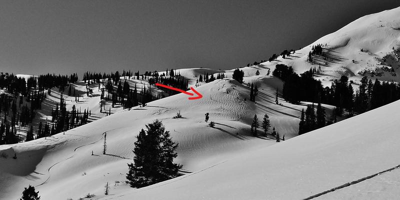
The avalanche danger is Moderate at the upper elevations for triggering a wind slab avalanche that could be 1-2 feet deep and up to 100 feet wide, and even wider in some terrain.
At elevations below, 8,500' the avalanche danger is Low, however, with warm temperatures and strong sunshine today, rollerballs and small, wet/loose avalanches will be possible on slopes facing southeast through west.
Low
Moderate
Considerable
High
Extreme
Learn how to read the forecast here
Special Announcements
Discounted lift tickets - Thanks to the generous support of our Utah ski resorts and Ski Utah, all proceeds from these ticket sales go towards paying for avalanche forecasting and education! Get your tickets here.

The UAC's Avy Awareness Auction is currently underway with tons of great gear, jewelry, artwork and experiences available. Visit the auction page HERE to help support the UAC's spring avalanche awareness and outreach efforts.
Weather and Snow
Currently: Temperatures range through the 20's F, with a temperature inversion at some low-elevation trailheads with temperatures in the single digits. Winds are out of the southwest and generally light below about 10,000'. Above that, winds are in the teens with gusts in the 20's. At 11,000' winds are gusting in the 20's and low 30's mph.
For Today: Sunny and warm. Temperatures will rise into the 30's, and near freezing along upper elevation ridges. Winds will be out of the south/southwest. At mid-elevations winds will average 10 mph with gusts in the teens. Along upper elevation ridges, averages will be in the teens with gusts in the upper 20's.
For This Weekend: Continued warm on Saturday with increasing clouds. The Ogden mountains are north of a storm system tracking well south of us, but we may get a trace to and inch of snow overnight Saturday into Sunday.
Recent Avalanches
Yesterday, in the Ogden backcountry adjacent to Snowbasin, a skier triggered an avalanche adjacent to Monday's full burial. This avalanche failed on weak snow above the February 7 crust.
Ad
Avalanche Problem #1
Wind Drifted Snow
Type
Location
Likelihood
Size
Description
Yesterday's avalanche in the backcountry adjacent to Snowbasin is a reminder pockets of sensitive wind drifts remain at the upper elevations. These wind drifts are on top of weaker snow that is sitting just above the February 7 crust. These avalanches can be triggered remotely, and the structure may allow a rider to get well onto a slope before it fractures. The photo below is from Monday's full burial in the backcountry adjacent to Snowbasin:
Avoid any wind-drifted slope on terrain steeper than 30 degrees. Signs of wind-drifting include denser pillows of snow or textured snow. The photo below from Derek Debruin is a nice illustration of wind-drfited snow.
General Announcements
This information does not apply to developed ski areas or highways where avalanche control is normally done. This forecast is from the U.S.D.A. Forest Service, which is solely responsible for its content. This forecast describes general avalanche conditions and local variations always occur.