Forecast for the Ogden Area Mountains

Trent Meisenheimer
Issued by Trent Meisenheimer on
Thursday morning, February 20, 2020
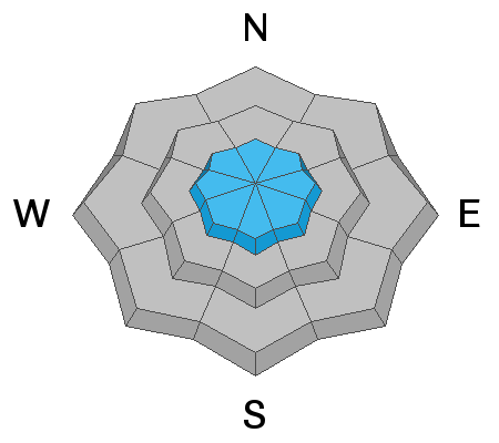
The avalanche danger is MODERATE at the upper elevations for triggering a wind slab avalanche that could be 1-2 feet deep and up to 100 feet wide, and in some terrain, it could be wider. Human triggered avalanches are possible. At elevations below, 8,500' the avalanche danger is LOW, and Normal Caution is advised.
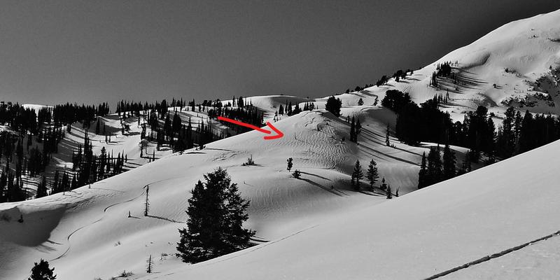
As the sun warms the sunny aspects today, we could see rollerballs and small wet loose avalanches by late afternoon. If you're on steep sunny slopes and see rollerballs and snow cascading down the mountain, it's time to get out of there. Change your aspect to a colder and shadier slope.
Low
Moderate
Considerable
High
Extreme
Learn how to read the forecast here
Special Announcements
Discounted lift tickets - Thanks to the generous support of our Utah ski resorts and Ski Utah, all proceeds from these ticket sales go towards paying for avalanche forecasting and education! Get your tickets here.
Weather and Snow
It will be another sunny and stunning day to be in the mountains. Mountain temperatures are currently influenced by a strong temperature inversion this morning with Ben Lomond Trail (6,000') reading 2°F and the top of James Peak (9,500') reading 19°F. Winds are calm and generally blowing 5-10 mph on the most exposed upper elevation ridgelines. For today, we can expect plenty of sunshine and light winds with temperatures climbing into the low 30's °F at 9,000'.
As a closed low sits off the coast of California, we will see an increase in temperatures and southerly winds for the next few days. The models are not in total agreement on where this storm ends up. Although, it's looking like a good storm for central and southern Utah with the possibility of a decent refresh here in the Wasatch. Stay tuned
The snow surface remains excellent in terrain that is protected from the wind and sun. On the sunny aspects, you can expect to find a crust and less desirable snow.
Recent Avalanches
None
Ad
Avalanche Problem #1
Wind Drifted Snow
Type
Location
Likelihood
Size
Description
All of the recent avalanche activity has been the result of very-low-density snow (weak layer) with denser more cohesive snow above (slab). This weaker snow is now buried 1-2 feet deep and is very easy to find because it sits just above the February 7th crust.
It seems the new snow has settled and stabilized and is no longer a problem in wind-sheltered terrain. However, in places that were affected by northerly winds, it remains possible to trigger a wind slab avalanche. Continue to look for and avoid Wind Drifted Snow that looks pillowy and textured. This snow will feel upside down and stiff.
Photo: Derek Debruin with a good example of Wind Drifted Snow.

Danger trend: decreasing
General Announcements
This information does not apply to developed ski areas or highways where avalanche control is normally done. This forecast is from the U.S.D.A. Forest Service, which is solely responsible for its content. This forecast describes general avalanche conditions and local variations always occur.