Forecast for the Ogden Area Mountains

Greg Gagne
Issued by Greg Gagne on
Monday morning, January 6, 2020
Today the avalanche danger is MODERATE at upper and mid elevations where recent and fresh slabs of wind drifted snow can be triggered. Shallow, but long-running sluffs, may be possible in the new snow on steeper slopes.
At low elevations, avalanches are unlikely and the danger is LOW.
Low
Moderate
Considerable
High
Extreme
Learn how to read the forecast here
Special Announcements
Get discount lift tickets HERE. Thanks for this generous support from Utah Ski Resorts and Ski Utah. All proceeds go directly to supporting the UAC.
Weather and Snow
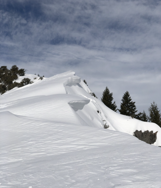
Currently, temperatures in the Ogden mountains range through the teens F, but moderate to strong westerly winds are making things feel much colder. At the mid elevations, winds, winds are averaging in the teens with gusts in the 20's mph. Above about 9,000' winds are averaging in the 20's and 30's mph, with gusts in the 50's atop Mt. Ogden.
Snowfall began mid-afternoon Sunday, but this storm ended up disappointing, with only 2-4" of snow reported by this morning. Fortunately, despite the low snowfall amounts, the fresh snow and winds smoothed out many snow surfaces providing fun riding and traveling conditions.
For today, you can expect clearing skies as the day progresses as high pressure moves into the region. Temperatures will reach the mid 20's F and winds will be out of the west/northwest. At mid-elevations winds will average in the teens with gusts in the 20's. Along upper elevation ridges winds will be much stronger, averaging in the 20's and 30's, with gusts in the 40's. Fortunately winds are forecasted to diminish as the day progresses.
Recent Avalanches
No avalanches were reported from the Ogden backcountry on Sunday. We did receive two observations from Ben Lomond on Sunday. These observations are invaluable for us, so please keep them coming!
Ad
Avalanche Problem #1
Wind Drifted Snow
Type
Location
Likelihood
Size
Description
Sustained winds the past several days have created wind drifts on a variety of aspects at the mid and upper elevations. This includes fresh drifts found near the surface, or drifts that formed this past weekend and are now buried underneath the snow surface.
Strong winds can work through terrain, depositing drifts on any aspect. Places where you can find fresh drifts include
- leeward aspects;
- open bowls;
- mid-slope rollovers;
- and cross-loading on gullies and other terrain features.
Wind-drifted snow can be easy to spot and avoid. It often looks round and pillowy, and it can sometimes feel hollow like a drum when you step onto a wind-loaded slope. The photo below from the North Ogden Divide illustrates a wind-loaded slope with cornices along the leeward aspects.
The best - and safest - riding conditions today will be on mid-elevation wind-protected slopes.
General Announcements
This information does not apply to developed ski areas or highways where avalanche control is normally done. This forecast is from the U.S.D.A. Forest Service, which is solely responsible for its content. This forecast describes general avalanche conditions and local variations always occur.