Forecast for the Ogden Area Mountains

Drew Hardesty
Issued by Drew Hardesty on
Tuesday morning, January 7, 2020
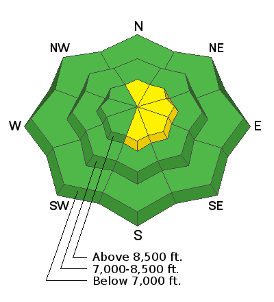
Most terrain has a LOW avalanche danger. Areas of MODERATE danger, however, exist for pockety human triggered wind drifts along the upper elevations.
Loose wet snow avalanches may be possible on the steepest sunlit slopes with daytime heating.
Low
Moderate
Considerable
High
Extreme
Learn how to read the forecast here
Special Announcements
Get discount lift tickets HERE. Thanks for this generous support from Utah Ski Resorts and Ski Utah. All proceeds go directly to supporting the UAC.
Weather and Snow
Skies are partly cloudy with mountain temps in the upper teens to low 20s. The northwesterlies are blowing 10-15mph with gusts to 20. The most exposed ridgelines have hourly averages of 20-25 with gusts to 30. Southerly aspects will be crusted this morning with soft settled powder found in the wind sheltered terrain. Snow depths range from 36' at the trailheads to 40-50" in the upper elevations.
For today we'll have increasing high thin clouds, backing winds, and temperatures rising to the mid-30s. A storm arrives tomorrow with perhaps 3-7" possible. The longer range models look active and progressive for the 7-10 day outlook.
Recent Avalanches
Ski area control work produced little more than pockety wind drifts and sluffing in the upper elevations.
Ad
Avalanche Problem #1
Wind Drifted Snow
Type
Location
Likelihood
Size
Description
Soft and hard wind drifts may be found in localized terrain and generally limited to the upper elevations. The last 48 hours have had southwest and northwest winds and drifts - though generally stubborn - may be found in steep lee terrain, mid-slope breakovers, and around other terrain features such as rocky outcroppings. Also, avoid the cornices along the high ridgelines.
IF the winds pick up earlier than expected, watch for an increasing hazard of fresh wind drifts.
The best - and safest - riding conditions today will be on mid-elevation wind-protected slopes.
General Announcements
This information does not apply to developed ski areas or highways where avalanche control is normally done. This forecast is from the U.S.D.A. Forest Service, which is solely responsible for its content. This forecast describes general avalanche conditions and local variations always occur.