Forecast for the Ogden Area Mountains

Greg Gagne
Issued by Greg Gagne on
Friday morning, January 3, 2020
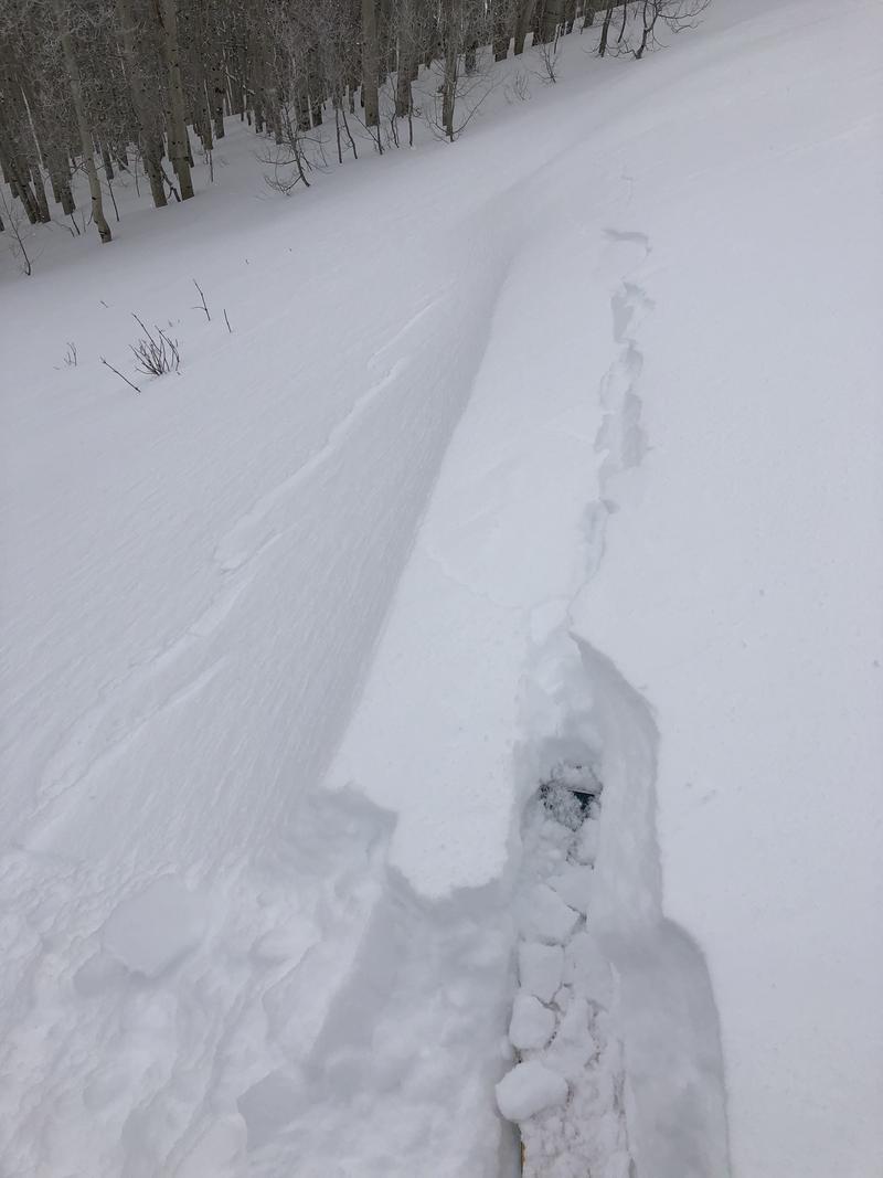
The avalanche danger is CONSIDERABLE on all upper aspects where human-triggered avalanches are likely on steeper, wind-drifted slopes. Avalanches on wind-drifted slopes may be triggered from below or on adjacent slopes. The avalanche hazard is Moderate on all mid and low elevation slopes
Low
Moderate
Considerable
High
Extreme
Learn how to read the forecast here
Special Announcements
Get discount lift tickets HERE. Thanks for this generous support from Utah Ski Resorts and Ski Utah. All proceeds go directly to supporting the UAC.
Weather and Snow
Currently, temperatures in the Ogden mountains range through the 20's F. Winds are westerly, and wind speeds are very elevation-dependent. At the upper elevations winds are averaging in the teens and 20's mph, with gusts in the 30's. Drop elevation and winds are much lighter with a few gusts in the teens. Storm totals for the New Years storm are 6-10" with up to 1.6" of water.
For today, expect partly cloudy skies with gradual clearing as high pressure briefly moves into our region. Temperatures will warm into the 20's and low 30's F. Winds will be out of the northwest remain strongest at the upper elevations, gusting into the 30's mph along upper elevation ridges. Drop elevation and wind speeds will be much more moderate, with exposed ridges averaging in the teens with gusts in the 20's mph.
Recent Avalanches
We received no reports from the Ogden backcountry on Thursday. Control work from Ogden-area resorts resulted in avalanches in fresh wind slabs, with some running up to 200' in distance.
Ad
Avalanche Problem #1
Wind Drifted Snow
Type
Location
Likelihood
Size
Description
Westerly winds the past several days continue to drift snow onto many mid and upper elevation slopes. Although you can expect to find fresh wind drifts on leeward aspects generally facing east, the wind can work through terrain and cross-load a slope on any aspect. Remotely-triggered slides on Wednesday are an indication these wind drifts may continue to be reactive today. Avoid wind-drifted slopes as avalanches can be triggered from below or on an adjacent slope. Watch for clues of wind loading such as cracking and wind-drifted pillows.
Although most observations indicate that avalanching will generally require a wind-loaded slope, the recent storm snow fell onto a weak, pre-existing snow surface, and sensitive shallow storm slabs 6-10" thick may be possible on steeper slopes. Signs to watch for include cracking and collapsing.
General Announcements
This information does not apply to developed ski areas or highways where avalanche control is normally done. This forecast is from the U.S.D.A. Forest Service, which is solely responsible for its content. This forecast describes general avalanche conditions and local variations always occur.