Forecast for the Provo Area Mountains

Evelyn Lees
Issued by Evelyn Lees on
Friday morning, February 22, 2019
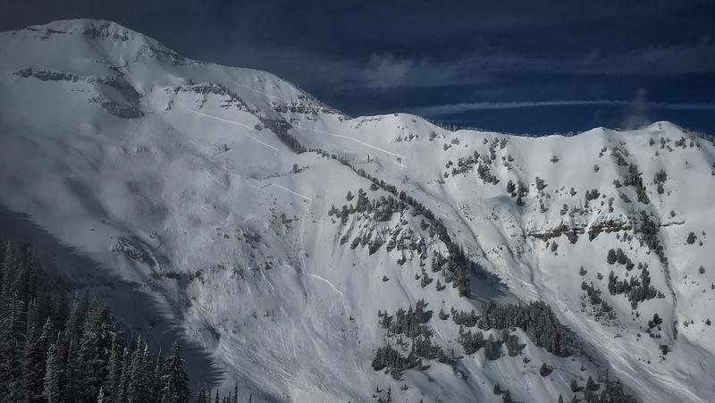
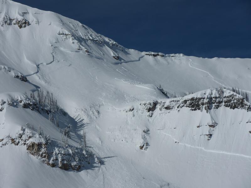
Do to uncertainty, the avalanche danger is the Provo area mountains is CONSIDERABLE on upper elevation slopes, especially those with recent wind drifts and aspects that have produced massive natural avalanches. Even though the likelihood of triggering one of these monsters is decreasing, the travel advice for this danger rating says: "Dangerous avalanche conditions. Careful snowpack evaluation, cautions route finding, and conservative decision making essential."
The avalanche danger is MODERATE at mid elevations, and generally LOW at low elevations. Be aware of what is above you and avoid lingering in run out zones of avalanche paths.
Low
Moderate
Considerable
High
Extreme
Learn how to read the forecast here
Special Announcements
Heading south for the weekend? Avalanche Warning for the Abajos and La Sals. There are forecasts for the Manti Skyline, La Sal and Abajo mountains. We do post obs from the mountains of southwest Utah. View them here or submit obs here.
Weather and Snow
Under cloudy skies, light snow has been falling, adding another 2 to 5” of low density powder in the Provo area mountains. Temperatures are once again cold - in the single digits at most stations, and are expected to only warm into the teens today. Skies should partially clear this afternoon, and the powder remains excellent.
The wind direction has been shifting around the last 24 hours, but has mostly been from the southeast. Today, it should eventually settle on northeasterly. Speeds are currently almost calm, but have averaged averaging averaging 10 to 15 mph at the mid to upper elevations, with gusts to 20 mph. Speeds are expected to stay light today. Canyon mouths like Parleys, Weber, Provo and Ogden are where the greatest speeds were overnight, and gusts in the 30s will continue for a while this morning. Late this afternoon or this evening, the winds will shift to the northwest and increase, with averages 15 to 25 mph, and gusts in the 30s.
Recent Avalanches
A very large natural avalanche that released in the Provo area mountains this week, after the storm was over. This slide was 5-9' feet deep and up to 2500' feet wide, running 3,000' vertical feet to the valley floor. (PC: UDOT)
Ad
Avalanche Problem #1
Wind Drifted Snow
Type
Location
Likelihood
Size
Description
Wind slabs: It will be another day of dodging the wind drifts at the upper and mid elevations. With the wind direction over the last 24 hours varying by drainage, drifts can be found on almost every aspect. North and northwesterly facing slopes were especially loaded by yesterday’s southeasterly winds. The abundant low density snow is forming both the weak layer and the soft slab. The best way to avoid these wind slabs is to look for them. Wind drifts are often rounded, smooth, and feel denser or “cakier” than the surrounding snow. Cracking in the snow is a sure sign of a wind drift. Also look for signs of new drifting - winds are forecast to shift to the northwest and increase late this afternoon and overnight. Watch for plumes off ridge lines and peaks above you and blowing snow where you are.
Sluffs - can be triggered on steep slopes of all aspects, running far distances in continuously steep terrain. They are large enough to catch and carry a person on foot.
The large cornices have become a permanent part of the landscape, and were joined by a few new smaller ones from yesterday’s easterly winds. The large, older ones will break back much further than expected - avoid travel below and on these.
Avalanche Problem #2
Persistent Weak Layer
Type
Location
Likelihood
Size
Description
Assessing the snowpack in the Provo area mountains in avalanche terrain at mid and upper elevations on NW, N, NE, E aspects (and upper elevation SE) is difficult. Recent natural avalanches have broken at the ground. With this type of avalanche it is very hard to assess what the likelihood of triggering one is. All we really know is that these slides have been MASSIVE and would be deadly to be caught in. The only mitigation strategy we have is to avoid avalanche terrain for now.
With such large cornices looming over many slopes, I'd would avoid run out zones. Cornices can break on their own and trigger more massive slides that could run down on top of you.
Photo: Zoomed in view of the natural avalanche that was spotted two days ago.
Additional Information
So how awesome has February been? One way to see is looking at how much water was contained in the snow. Mark created this graph, and a whole blog with more details HERE.
The accident reports for the four avalanche fatalities are all finalized with some first-hand accounts and worth reading. We all have something to learn so that we can get home safely to our loved ones. List of all accidents found HERE.
General Announcements
This information does not apply to developed ski areas or highways where avalanche control is normally done. This forecast is from the U.S.D.A. Forest Service, which is solely responsible for its content. This forecast describes general avalanche conditions and local variations always occur.