This morning under mostly clear skies the mountain temperatures range from the low to upper 30s F. Winds are south-easterly and lightly blowing 0-10 mph with gusts up to 15 mph at mid-elevations. Upper elevation winds are 15-20 mph, with gusts up to 30 mph.
Today will bring increased cloud cover and eventually scattered showers this afternoon. Temperatures should climb into the 40s and low 50s F. Winds will become easterly and continue to be light, gusting up to 30 mph at the highest elevations. This increased moisture could bring 1-2 inches of snow to the Ogden area before more dry weather tomorrow.
Another night of clear skies, near-freezing temperatures, and low relative humidity will have allowed for a generally good overnight refreeze at mid and upper elevations, leaving a firm supportable riding surface at these elevations this morning.
Wet snow - Multiple signs of wet snow reported in the backcountry, including roller balls, pinwheels and easily triggered small wet-loose avalanches. Some of this natural activity was observed midday yesterday on
Mt. Ogden on a North-East aspect at 9300'.
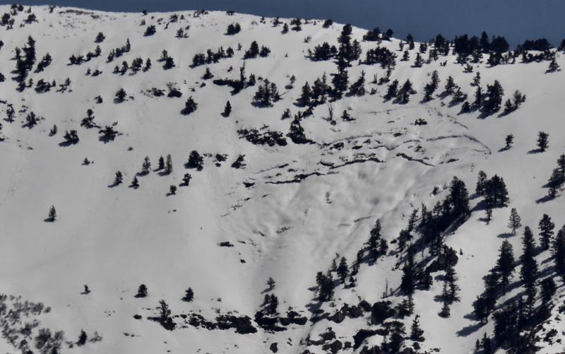
Glide Avalanches - Yesterday there was evidence of multiple Glide Avalanches that were reported in the backcountry. In the Ogden area, glide activity was seen above
North Ogden from I-15. In the Central Wasatch, multiple glide avalanches were reported. One of these glide avalanches was reported in
Stairs Gulch. The other two glide avalanches were reported in Broads Fork on
Bonkers and
Blue Ice.
This occurs when a previously open glide crack releases and the entire snowpack slides as a unit to the ground. While these tend to be unpredictable, multiple occurring within a small time frame indicates conditions are currently suitable for these to release.
Find the full observation page
HERE.