Forecast for the Ogden Area Mountains

Drew Hardesty
Issued by Drew Hardesty on
Sunday morning, February 24, 2019
A MODERATE danger exists for recent and developing wind drifts today. The drifts will be most pronounced on steep north to east to south facing slopes above about 8000'...and pockety elsewhere. Watch for sluffing in the steepest, most confined terrain. Wind sheltered terrain has a generally LOW danger.
With additional snow and wind in the forecast, the danger will be on the rise for tomorrow.
Low
Moderate
Considerable
High
Extreme
Learn how to read the forecast here
Special Announcements
New Blog post - Low Danger - Chapter 1 - We're All in This Together
New Blog-cast - I AM Dangerous

Catch up on the past week of snow, weather and avalanches with Greg Gagne’s Week in Review.
Weather and Snow
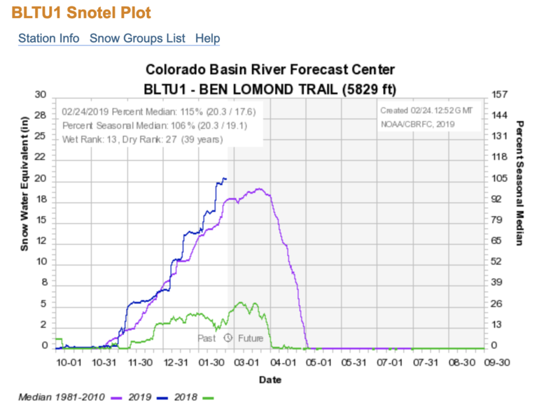
Skies are partly cloudy this morning with warming temperatures and increasing west to southwest winds. As of 4am, temps are in the mid teens to low 20s. Winds increased overnight and are blowing 20-25mph with gusts to 30. It's been a good run this year with many snow stations sitting at 120%+ of average. Below you'll see a screen capture of the Ben Lomond trail snotel site at elevation 5830' in the north fork. You can find a statewide map here.
For today we'll have partly cloudy - becoming mostly cloudy skies and then completely overcast by tonight. A series of storms passing by to the north will keep most of the snow in Idaho and Wyoming but the scraps left behind will be enough for more snow tomorrow (4-8") and more during the week. More snow in the Bear River Range. Today's temps will reach the upper teens. Winds will be increasing to 25mph+ along the ridgelines.
Recent Avalanches
Isolated medium to hard wind slabs noted at the ski resorts.
Ad
Avalanche Problem #1
Wind Drifted Snow
Type
Location
Likelihood
Size
Description
Be on the lookout for recent and developing shallow wind drifts along the higher elevations today. The low density snow will easily move with the slowly increasing westerlies today and tomorrow. These drifts may be up to a foot+ deep and more pronounced on steep north to east to south facing slopes above 8000'. Due to terrain channeling, pockety drifts may be found in the mid-elevation of all aspects. Take note that it may be possible for some drifts to be triggered remotely (at a distance). Cornices remain unwieldy and should be treated with suspicion.
Additional Information
As always, you can find great info on Instagram ogdenavalanche and #ogdenavalanche
General Announcements
This information does not apply to developed ski areas or highways where avalanche control is normally done. This forecast is from the U.S.D.A. Forest Service, which is solely responsible for its content. This forecast describes general avalanche conditions and local variations always occur.