Forecast for the Ogden Area Mountains

Mark Staples
Issued by Mark Staples on
Tuesday morning, February 18, 2020
The avalanche danger is CONSIDERABLE at all upper elevations where soft slabs of new snow and wind drifted snow can easily be triggered today.
At mid elevations, human triggered avalanches are definItely possibile but not a widespread issue and the danger is MODERATE.

At low elevations with less snow and less wind, the avalanche danger is LOW.
Low
Moderate
Considerable
High
Extreme
Learn how to read the forecast here
Special Announcements
Discounted lift tickets - Thanks to the generous support of our Utah ski resorts and Ski Utah, all proceeds from these ticket sales go towards paying for avalanche forecasting and education! Get your tickets here.
Weather and Snow
Yesterday: Despite strong sunshine in the morning, high temperatures reached high teens and low 20s F before increasing clouds and cold air stopped further warming. Due south-facing slopes warmed just enough to dampen the snow and create a very thin crust which may not exist on southwest or southeast facing slopes.
This morning: It's COLD with temperatures a little above and below 10 degrees F. Fortunately light winds from the west are blowing 5-10 mph.
Today: Skies will be mostly sunny with a few clouds. Temperatures will only climb into low 20s F. Westerly winds should remain light.
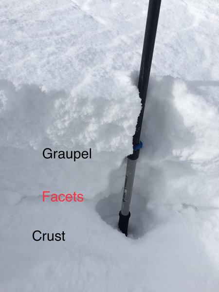
Snowfall totals from Sunday/Monday are 8-10" snow (0.80" - 0.90" water)
Recent Avalanches
There were two notable avalanches yesterday. One avalanche occurred in the backcountry near Snowbasin. A skier and snowboarder without any rescue gear triggered an avalanche that fully buried the skier who fortunately had a ski tip sticking out of the snow and was found uninjured after about 4 minutes.
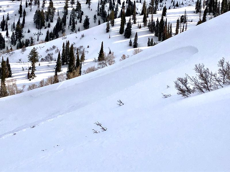
Another slide occurred on Ben Lomond Peak (photo below), when a skier triggered a slide 12 inches deep and 300 feet wide. The party involved wrote a detailed account HERE that is worth reading.
Additionally local ski patrols easily triggered many slides in the new snow that were big enough to bury a person.
Ad
Avalanche Problem #1
New Snow
Type
Location
Likelihood
Size
Description
The main avalanche issue is a layer of dense snow resting on a layer of very light and fragile snowflakes and/or graupel (photo below - D. Hummer). On many slopes this layer rest on top of an ice crust or other firm layers allowing avalanches to run far.
Normally, weak layers of soft new snow can stabilize quickly. What is unique about layering in the upper 2 feet of the snowpack is dramatic hardness differences. These differences should keep this avalanche issue alive today. You can easily feel these changes in hardness if you dig with your shovel or poke into the snow with a ski pole.
Another issue that may keep the new snow unstable a little longer than normal is the possibility of some weak faceted snow on top of a crust that formed on Feb 7th. This issue surprised an experienced observer in the Ogden area while skiing on Ben Lomond Peak. On many slopes, this layer was scoured by strong winds prior to Sunday's snowfall. On other slopes this layer remains intact and can produce avalanches. The trouble is that you may not see signs of instability until it's too late.

Danger trend: decreasing
Avalanche Problem #2
Wind Drifted Snow
Type
Location
Likelihood
Size
Description
Winds Sunday night were the strongest with some gusts of 50 mph recorded. These winds formed soft slabs of drifted snow that most likely exits at upper elevations. Today's light winds shouldn't be transporting any more snow and will allow these drifts to begin stabilizing.
Winds have mostly been blowing from the northwest and west, but look for drifting on all aspects which can be loaded from the tops of ridges or across the sides of ridges. Visual signs of wind drifted snow include smooth, rounded, pillowly appearances.
Danger trend: decreasing
Additional Information
LOOKING BACK:
Before this storm cycle, 2-4” rested on top of a widespread rain/rime crust that formed late Friday, February 7th (The "Dickens Crust"? February 7 is Charles Dicken's birthday and this crust may prove to be the dickens!). The cold temperatures began to weaken, through a process called faceting, the snow both above this layer. In some places a combination of warm daytime temperatures and sunshine healed this layer. In other places this layer survived and has been buried.
The problem with this layer is that many slopes will remain unstable and will easily produce avalanches. Other slopes that do not have this layer will stabilize much more quickly in coming days.
General Announcements
This information does not apply to developed ski areas or highways where avalanche control is normally done. This forecast is from the U.S.D.A. Forest Service, which is solely responsible for its content. This forecast describes general avalanche conditions and local variations always occur.