Forecast for the Ogden Area Mountains

Greg Gagne
Issued by Greg Gagne on
Friday morning, December 25, 2020
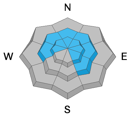
There is a CONSIDERABLE avalanche danger upper elevations on aspects facing west, north and east for triggering avalanches that are 1-2' deep and over a hundred feet wide. Avalanches may be triggered remotely and from lower-angled terrain. Avoid being on, underneath or adjacent to slopes greater than 30°in steepness on these upper elevation aspects.
On mid and upper elevation southerly aspects there is a MODERATE danger.
Low elevations have a Low danger.
Low
Moderate
Considerable
High
Extreme
Learn how to read the forecast here
Special Announcements
Thanks to the generous support of our local resorts, Ski Utah, and Backcountry, discount lift tickets are now available.
Support the UAC while you ski at the resorts this season. Tickets are available here.
Weather and Snow
Allure of fresh snow.
Persistent weakness. One should
read Mary Ruefle.

This Morning: Some high thin clouds and temperatures range through the 20's F. Winds are out of the south/southwest and generally light - less than 10 mph - with gusts in the 20's mph along the upper elevation ridgelines.
For Today: High thin clouds with clearing this afternoon. Temperatures will remain mild, rising slightly above freezing in most mountain locations, with lower-elevations reaching the mid 30's F. Winds will be out of the southwest and remain generally light, with an uptick this afternoon with gusts in the 20's mph at the upper elevations.
This Weekend: Increasing clouds tonight with a weak system for Saturday which may bring a few inches of light snow. Looking further ahead, chances for light snow early this coming week and then perhaps right around the New Year.
Recent Avalanches
No reports of recent avalanche activity apart from a reported catch-and-carry in Bailey Spring area adjacent to Cutler Ridge on Ben Lomond this past Sunday.
Ad
Avalanche Problem #1
Persistent Weak Layer
Type
Location
Likelihood
Size
Description
There is a layer of weak faceted snow at the mid and upper elevations on aspects facing west, through north, and southeast. The photo below from Hell's Canyon illustrates this weak snow at the base of the snowpack: [Photo: Jared Allen]
UAC forecaster Nikki Champion was on Cutler Ridge yesterday and shares what she found in this video (read her excellent full observation):
Avoid slopes steeper than 30° on upper elevation aspects facing west, through north, and east. Triggering an avalanche on these slopes is likely; they may be up to 1-2' deep and over a hundred feet wide.
The good news is that low-angled slopes in non-avalanche terrain are riding quite well!
General Announcements
Please visit this website with information about Responsible Winter Recreation by the Utah Office of Outdoor Recreation.

This information does not apply to developed ski areas or highways where avalanche control is normally done. This forecast is from the U.S.D.A. Forest Service, which is solely responsible for its content. This forecast describes general avalanche conditions and local variations always occur.