Forecast for the Ogden Area Mountains

Greg Gagne
Issued by Greg Gagne on
Tuesday morning, December 25, 2018
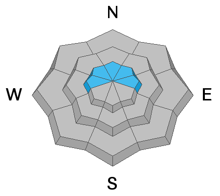
The avalanche hazard for the Ogden mountains is mostly LOW, with a MODERATE hazard at the upper elevations facing west, north, and east for fresh wind slabs. Although unlikely, you also may encounter pockets of sensitive storm snow at the very upper-most elevations.
From our entire team at the Utah Avalanche Center, we wish you all a Very Merry Christmas!
Low
Moderate
Considerable
High
Extreme
Learn how to read the forecast here
Special Announcements
The new UAC IOS mobile app is now available on the app store. Check out the new "My Weather" feature.
Weather and Snow
Temperatures this morning in the Ogden mountains are in the low 20's F and winds are out of the southeast, gusting into the 20's at the upper elevations. Yesterday the Ogden mountains received 3-6" of snow, and overnight we received a stocking-stuffer gift with an additional trace to 2” of new snow.
For today temperatures are expected to remain in the 20's and winds will be out of the southeast and light, with gusts in the 20's along the upper elevation ridges. Wind speeds should diminish by later this afternoon. We may pick up a few inches of snow during the day.
Recent Avalanches
The only reports we received from the Ogden mountains on Monday included sensitive storm snow early Monday morning during periods of higher precipitation.
Ad
Avalanche Problem #1
Wind Drifted Snow
Type
Location
Likelihood
Size
Description
Overnight wind speeds increased while shifting from the southwest to the southeast. With fresh snowfall available to work with, you may find fresh wind slabs on upper elevation aspects facing west, through north, and east. Although any drifts you encounter should be small, they may be sensitive, especially early this morning.
Although winds are forecasted to diminish as the day progresses, we typically are not used to southeast winds as they create unusual loading patterns. Watch for drifting in unlikely places (such as westerly aspects), especially if winds become more easterly.
General Announcements
This information does not apply to developed ski areas or highways where avalanche control is normally done. This forecast is from the U.S.D.A. Forest Service, which is solely responsible for its content. This forecast describes general avalanche conditions and local variations always occur.