Forecast for the Ogden Area Mountains

Greg Gagne
Issued by Greg Gagne on
Monday morning, December 24, 2018
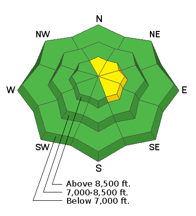
The avalanche hazard for the Ogden mountains is mostly LOW, with a MODERATE hazard at the upper elevations facing north, through east, then southeast for fresh wind slabs. Watch for rounded pillows of fresh drifts as well as cornices along upper elevation ridgelines. Also watch for sensitive storm snow, especially during the morning hours if snowfall rates increase.
Low
Moderate
Considerable
High
Extreme
Learn how to read the forecast here
Special Announcements
The new UAC IOS mobile app is now available on the app store. Check out the new "My Weather" feature.
Weather and Snow
Temperatures this morning in the Ogden mountains range through the 20's F and westerly winds are generally light,with a few moderate gusts in the teens mph. A trace to 3" of snow has fallen overnight.
The recent storm snow has settled out to 6-8", providing good riding conditions on a soft and supportable snow surface.
I guess we weren't as good as I thought we've been. We may pick up another trace to 2” of snow before partial clearing this afternoon. Winds will be westerly, averaging in the teens and 20’s mph, with gusts in the 30’s mph at the higher elevations. Winds are expected to diminish as the day progresses. Mountain temperatures will be in the 20’s F. We may pick up another trace to 2" overnight, and a few inches possible later on Christmas night. A chance for snow showers later this week, with colder temperatures.
Recent Avalanches
There were no reports of avalanches in the Ogden mountains for Sunday.
Ad
Avalanche Problem #1
Wind Drifted Snow
Type
Location
Likelihood
Size
Description
You may find fresh wind slabs along the upper elevation ridge lines from recent westerly winds. Although any drifts are expected to be small, some drifts may be hard, allowing you to get well onto the slab before it fractures. Also watch for fresh cornices overhanging leeward aspects from westerly winds.
General Announcements
This information does not apply to developed ski areas or highways where avalanche control is normally done. This forecast is from the U.S.D.A. Forest Service, which is solely responsible for its content. This forecast describes general avalanche conditions and local variations always occur.