Forecast for the Ogden Area Mountains

Drew Hardesty
Issued by Drew Hardesty on
Sunday morning, February 21, 2021
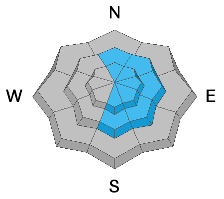
Areas of CONSIDERABLE avalanche danger exist on many slopes of the mid and upper elevations. Considerable means that dangerous human triggered avalanches are likely. The danger is more prevalent on west to north to southeast facing slopes and on any recently wind drifted terrain. Cornices are to be avoided.

All the experienced backcountry riders I know are setting wide margins of safety and continue to rule out steep terrain for now.
The Good News: Safe and enjoyable powder can be found on low angle slopes with no overhead hazard.
Low
Moderate
Considerable
High
Extreme
Learn how to read the forecast here
Special Announcements
On Monday, February 22, at 7 PM, the UAC will livestream a one hour review and debrief of the tragic Wilson Glades avalanche accident, followed by a Q & A period. The link for registration is HERE.
A good primer for this will be to listen in to Friday's RadioWest conversation about avalanches and the incident. Stream it here or wherever you get your favorite podcasts.
Weather and Snow
Skies are mostly cloudy this morning in the wake of the storm. The Ogden mountains picked up 4-6" yesterday and riding conditions are excellent despite some wind and rime damage here and there.
Mountain temperatures have plummeted with the passing wave and are in the mid to low teens. West to northwest winds are 15-20mph and perhaps twice that along the crest of the skyline.
Skies will trend partly cloudy this afternoon with mountain temps in the teens up high, the mid 20s down low. Temps trend warmer tomorrow.

It finally feels like we have a real winter under our feet - coverage is pushing 60-80" in the mid and upper elevations.
Recent Avalanches
Dangerous avalanche conditions consume the West: The backcountry community has suffered 22 avalanche fatalities in 22 days, the most recent from Idaho and Wyoming. INFO. Utah is up to 6 avalanche fatalities for the season.

Ski area control teams and backcountry travelers along the higher alpine ridgelines noted both sensitive cornices and sensitive but shallow wind drifts yesterday. Some cornices calved naturally and triggered wind slabs below, noted both along the Ogden skyline and the Ben Lomond headwall. Thanks DeBruin and Melton for the obs yesterday.
We did not hear of any avalanches breaking into deeper layers.
Ad
Avalanche Problem #1
Persistent Weak Layer
Type
Location
Likelihood
Size
Description
I am concerned with steep wind loaded terrain with basal weak layers. Avalanches in these layers have not been as prevalent as in SLC and Provo, but patience is key for me as consequences speak for themselves.
I anticipate that a few people will begin stepping out into steeper terrain today but the difference between joy and terror is sometimes just a matter of a few degrees of separation. As in about 10° of separation. You can find just as much joy on low angle terrain as you can on steep high angle terrain today. The options are simple.
Low Risk - High Reward
High Risk - High Reward

I will say that this takes discipline to stay the course and not drift into steeper terrain, even if you see tracks on those slopes. With this type of tricky snow structure, tracks offer zero indication of stability. Similarly, you may not experience any cracking or collapsing. No matter - patience is required. You are still likely to trigger a deeper slab avalanche 2-5' deep where the slab is thinner, in steep rocky terrain, or in areas that have avalanched previously this winter. I would not trust the steep terrain of the Snowbasin backcountry.
The Key is to do the Work-
  • Ski cuts and cornice drops can be dangerous and dangerously misleading indicators of stability
  • Dig down and if you see weak facets in the snowpack, avoid steep terrain
  • Choose a completely safe uptrack. You are often more vulnerable while ascending.
  • Expose only one person at a time and keep tabs on people all the time
Avalanche Problem #2
Wind Drifted Snow
Type
Location
Likelihood
Size
Description
Lingering wind drifts and cornices may still be sensitive to provocation today and will be more prevalent in the upper elevations or just to the lee of some of the more exposed mid-elevation ridgelines. A triggered wind slab or cornice may or may not step down into deeper weak layers. Shooting cracks can be good indicators of wind slab development.
Minor sluffing in the new snow can be expected in the steepest terrain.
General Announcements
Please visit this website with information about Responsible Winter Recreation by the Utah Office of Outdoor Recreation.

This information does not apply to developed ski areas or highways where avalanche control is normally done. This forecast is from the U.S.D.A. Forest Service, which is solely responsible for its content. This forecast describes general avalanche conditions and local variations always occur.