Forecast for the Ogden Area Mountains

Drew Hardesty
Issued by Drew Hardesty on
Monday morning, December 28, 2020
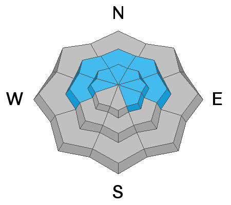
Areas of CONSIDERABLE danger exist on many west to north to easterly facing aspects. Human triggered avalanches 1-2' deep remain likely and these may be triggered on, adjacent to, or below steep slopes. A MODERATE danger exists for fresh drifts of wind blown snow in the mid and upper elevations.
Statistical Note - Most avalanche accidents occur when we have a Considerable danger with a persistent weak layer. Just saying.
Low
Moderate
Considerable
High
Extreme
Learn how to read the forecast here
Special Announcements
The Utah Avalanche Center podcast's second episode of season 4 is live - Managing Risk with Avalanches, Managing Risk with a Pandemic - A Conversation with state epidemiologist Dr. Angela Dunn
Stream here or tune in wherever you get your favorite podcasts
Thanks to the generous support of our local resorts, Ski Utah, and Backcountry, discount lift tickets are now available.
Support the UAC while you ski at the resorts this season. Tickets are available here.
Weather and Snow
Skies are mostly cloudy as a storm dives to our south. We may see a couple inches of new snow but that's about it. Winds picked up out of the east overnight and are blowing 20mph with gusts to 30. Mountain temps are in the teens. Snow depths are generally 18-24" and riding conditions are much improved with Saturday's new snowfall of 4".
The weather outlook over the next week or so looks progressive. I'm not seeing any blockbuster storms, but we seem to have a storm roll through every few days that should produce some snow. Which is a good thing. Currently we sit at 65% of normal. (Ski trip to the City of Rocks, anyone?)
Recent Avalanches
No new avalanches were reported in the Ogden area mountains yesterday, though nearly all folks in the backcountry reported collapsing and cracking in the fragile snowpack.
Thanks to Derek DeBruin, Doug Wewer, and Ben/Den Bauter for their keen perspective on the snowpack.
You can find their observations HERE.
Ad
Avalanche Problem #1
Persistent Weak Layer
Type
Location
Likelihood
Size
Description
The slab is slowly consolidating and avalanches are becoming more stubborn to trigger. That said, the weak layer remains as weak as ever and not to be trusted. Collapsing and cracking are key indicators of instability and are signs to keep your slope angles below 30 degrees. The most suspect terrain is on west to north to easterly facing aspects.
It may be awhile before the snow structure improves.
Avalanche Problem #2
Wind Drifted Snow
Type
Location
Likelihood
Size
Description
DON'T be surprised to find wind drifts in unusual areas today. East winds - particularly east winds that find their way into the mid-elevation bands - tend to load areas that catch people off guard. Try to have north to west to south facing slopes on your radar as potentially suspect. These drifts may be up to a foot deep and I wouldn't be surprised to hear of one triggered at a distance on south or west facing aspects.
REMEMBER that any slide triggered on west to north to easterly facing terrain may step down into older snow layers, resulting in a much more destructive avalanche.
Additional Information

The Selection of Desires
At the 2014 International Snow Science Workshop, long time Canadian (and Utah expat) heliski guide Roger Atkins presented a paper called Yin, Yang, and You. It was a watershed moment regarding communication of how we adjust our terrain selection in response to avalanche conditions. But hidden away in the essay was a paragraph or two called The Selection of Desires. A beautifully piece about these things in life that bring us joy. The hidden gem is that if the only thing that brings us joy is the steep and the deep....we may not last very long. The excerpt is HERE.
General Announcements
Please visit this website with information about Responsible Winter Recreation by the Utah Office of Outdoor Recreation.

This information does not apply to developed ski areas or highways where avalanche control is normally done. This forecast is from the U.S.D.A. Forest Service, which is solely responsible for its content. This forecast describes general avalanche conditions and local variations always occur.