Forecast for the Ogden Area Mountains

Greg Gagne
Issued by Greg Gagne on
Friday morning, December 18, 2020
An Avalanche Warning has been issued and the avalanche danger is HIGH on all aspects at the upper elevations. Travel in avalanche terrain is not recommended. Stay off of and out from underneath slopes 30° degrees and steeper at the mid and upper elevations. If you trigger an avalanche, it is likely to break down 12-18" and over a hundred feet wide.
The avalanche danger is Considerable at the mid-elevations, and Moderate at the low elevations.
Low
Moderate
Considerable
High
Extreme
Learn how to read the forecast here
Avalanche Warning
THE AVALANCHE DANGER FOR THE MOUNTAINS OF NORTHERN AND CENTRAL UTAH, INCLUDING THE WASATCH RANGE...THE WESTERN UINTAS AND THE MANTI-SKYLINE PLATEAU IS HIGH. RECENT HEAVY SNOWFALL AND DRIFTING FROM STRONG WINDS HAS CREATED WIDESPREAD AREAS OF UNSTABLE SNOW. HUMAN TRIGGERED AND NATURAL AVALANCHES ARE LIKELY. TRAVEL IN AVALANCHE TERRAIN IS NOT RECOMMENDED. STAY OFF OF AND OUT FROM UNDERNEATH SLOPES STEEPER THAN 30 DEGREES.
Weather and Snow
Currently, temperatures range through the teens F and winds are from the west/northwest. At mid elevations winds are averaging around 10 mph, with gusts in the teens. Atop Mount Ogden winds are averaging in the teens with gusts in the 20's mph.
Storm totals since Thursday morning range from 8-10", with nearly 1" of water.
For today, expect mostly-cloudy skies with occasional snow flurries, although additional totals should be at most 1-2". Temperatures will reach the upper teens F. Winds will be northerly, averaging in the teens with gusts in the 20's mph at mid elevations, and averages in the 20's mph with gusts near 30 mph along the highest ridges.

Recent Avalanches
We received no reports from the Ogden backcountry on Thursday. Further south in the Salt Lake mountains it was very active, and I suspect it will be easy to find similar conditions in the Ogden zone today. Below is a summary of the activity from the Salt Lake mountains:
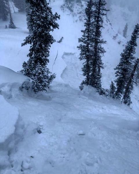
There were six human-triggered avalanches reported from Thursday. What is noticeable of these slides is many were triggered remotely (from a distance) failing in weak faceted snow that is now buried 18-30" deeply, an indication of the fragility of our weak snowpack structure:
- Two in Days Fork (Days Draw and Chicken S*!t Ridge)
- No Name Bowl Park City Ridgeline (10" deep, 30' wide, 450' vertical)
- Emma Ridgeline
- Catherine's Pass (18" deep, 250' wide, ran 200-300' vertical)
- Dog Lake Chutes in the Brighton backcountry (2' deep, 175' wide, 300' vertical)
The Dog Lake Chutes slide really got the attention of the Salt Lake forecasters due to its size and remote trigger:
In the video below, Mark Staples discusses the avalanche he and UAC colleague forecaster Nikki Champion triggered in Days Fork on a 30° slope.
Ad
Avalanche Problem #1
Persistent Weak Layer
Type
Location
Likelihood
Size
Description
Weak faceted snow from storms in early and mid November are present on aspects facing west, through north, and then southeast at the mid and upper elevations. Over this past week, the Ogden mountains received 6-8" or snowfall with nearly an inch of water. Over the past 12-18 hours, we quickly added around another 8-10" of snow, nearly an inch of water, and threw in some strong winds at the mid and upper elevations. This is enough of a load to make the weak faceted snow reactive.
At the upper elevations, you are very likely to trigger an avalanche in terrain steeper than 30° that has the persistent weak layer of faceted snow buried underneath the storm snow. These avalanches can be triggered remotely and from below.
Avalanche Problem #2
New Snow
Type
Location
Likelihood
Size
Description
Several observations from Thursday indicated sensitive storm snow during periods of higher precipitation intensity (PI), especially later in the day. You may find sensitive storm slabs in areas that received the most snow (approaching a foot) or in areas that also had some wind-drifting. Triggering an avalanche that initially fails in storm or wind-driven snow will likely break down more deeply into the weak faceted snow down 12-18".
Additional Information
Writing an avalanche forecast is a team process. On Thursday evening, Salt Lake forecasters Trent Meisenheimer, Mark Staples, and Greg Gagne discussed current conditions and thoughts for putting out Friday's forecast. We like to share these with the public so you have a bit better of an idea of how we communicate and the shared thinking that goes into each forecast.
General Announcements
Please visit this website with information about Responsible Winter Recreation by the Utah Office of Outdoor Recreation.

This information does not apply to developed ski areas or highways where avalanche control is normally done. This forecast is from the U.S.D.A. Forest Service, which is solely responsible for its content. This forecast describes general avalanche conditions and local variations always occur.