Forecast for the Ogden Area Mountains

Trent Meisenheimer
Issued by Trent Meisenheimer on
Wednesday morning, March 11, 2020
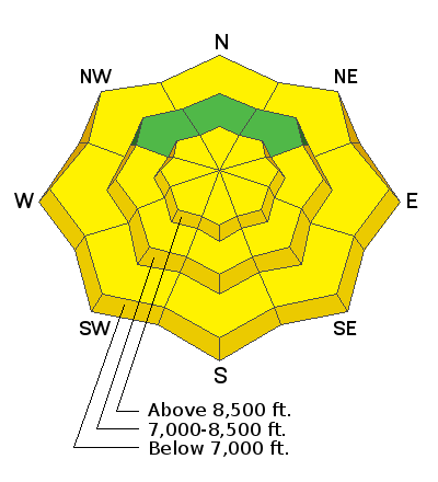
A lot of terrain has a LOW avalanche danger. Areas of MODERATE danger, however, do exist for wind drifts in (but not limited to) the upper elevations. These will be most pronounced on steep northwest to northeast to south-facing slopes.
Wet avalanches will be possible with any clearing (strong sun) on the steeper sunlit slopes and lower elevation shady slopes.
Low
Moderate
Considerable
High
Extreme
Learn how to read the forecast here
Special Announcements
Join The Utah Avalanche Center at Backcountry HQ on March 12th as Craig Gordon leads an interactive discussion on current Wasatch snowpack conditions, a recap of this season’s close calls and accidents, how to stay on the right side of the fracture line, and predictions for the rest of the season. Space is limited, registration is required. Register HERE.
Weather and Snow
Under mostly clear skies, the mountain temperatures only bottomed out in the mid 30's °F allowing for at best a very shallow re-freeze of the snow surface on the low to mid-elevation terrain. Winds overnight backed to the southwest and are currently blowing 15-20 mph gusting into the mid and upper 20's at ridgeline. Ogden peak is currently blowing southwest 25-30 mph gusting into the 40's.
For today, we will see increasing clouds streaming overhead as a closed low off the coast of California ejects moisture ahead of the storm. Winds will remain from the southwest for much of the day at speeds of 10-20 mph across the upper elevations. The sky cover will vary a lot today with filtered sun, partly cloudy, to cloudy skies at times. It is spring after all. This afternoon a shallow cold front will cross into northern Utah around 3:00 pm; winds will veer north and bring some snow showers to the mountains with 1 to 4 inches of new snow possible. Next week could be the return to winter. Stay tuned
Recent Avalanches
No new avalanches were reported from the backcountry. I would bet yesterday most areas saw a small wet loose avalanche cycle on the southerly facing terrain due to the intense March sun.
Ad
Avalanche Problem #1
Wind Drifted Snow
Type
Location
Likelihood
Size
Description
Continued winds overnight will keep a mention of wind drifted snow primarily along the higher elevation bands as well as a few pockets of wind drifts just to the lee of some mid-elevation ridgelines. These wind slabs may be up to a foot deep and 100' wide and reactive to cornice drops and slope cuts.
Avalanche Problem #2
Wet Snow
Type
Location
Likelihood
Size
Description
Wet snow avalanches can be exceptionally challenging to forecast, particularly with variable cloud cover. The good news is this problem is easily managed by paying attention to the snow you're riding on. If the snow is dry (powder) or frozen, then there is no problem, and you should turn your focus to wind drifted snow.
Pay attention to how the snow is behaving under your feet. Look for pinwheels, rollerballs, and punchy snow. Avoid being in or above terrain traps and steep-walled gullies. Wet avalanches may also be possible in the low - approaching mid-elevation - shady slopes due to marginal cooling.
General Announcements
This information does not apply to developed ski areas or highways where avalanche control is normally done. This forecast is from the U.S.D.A. Forest Service, which is solely responsible for its content. This forecast describes general avalanche conditions and local variations always occur.