Forecast for the Ogden Area Mountains

Greg Gagne
Issued by Greg Gagne on
Wednesday morning, December 25, 2019
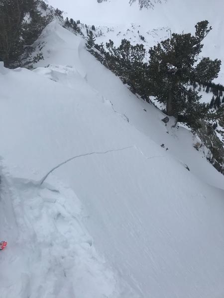
A MODERATE hazard exists at the upper elevations on aspects facing northwest through east for triggering isolated pockets of sensitive wind drifts as well as shallow sluffs in loose storm snow. All other terrain has a generally Low hazard.
Low
Moderate
Considerable
High
Extreme
Learn how to read the forecast here
Special Announcements
Stocking Stuffers: Thanks to the generous support of our Utah ski resorts and Ski Utah, we have discount lift tickets available. All proceeds from these go towards paying for avalanche forecasting and education! Get your tickets here.
Weather and Snow
Currently: Temperatures in the Ogden mountains range through the 20's F. Winds have diminished significantly since Tuesday afternoon. They are out of the west/northwest and very light, with a few gusts in the teens mph. Overnight snowfall totals range from 1-4".
For today, you can expect periods of snow showers with another 1-3" expected during the day. Winds will be from the west/northwest and light, with a few gusts in the teens at the uppermost ridgelines.
Recent Avalanches
There were no reports of avalanches in the backcountry on Tuesday. Patrollers at Ogden-area resorts reported long-running sluffs in the storm snow as well as pockets of sensitive wind drifts at the upper elevations.

We have received several excellent observations from the Ogden backcountry over this past week. You can see all Ogden-area observations here. Please keep sending them in!
Ad
Avalanche Problem #1
Wind Drifted Snow
Type
Location
Likelihood
Size
Description
Although the winds have diminished since Tuesday afternoon, you may still find an isolated wind drift at the upper elevations on aspects facing northwest through northeast, and southeast. Watch for signs of sensitive wind drifts such as cracking, as shown in the photo below (A & B photo) taken yesterday on a northerly aspect in Cardiff Fork in the Salt Lake mountains:
Although there isn't much new snow, shallow sluffs in loose snow are also possible on steeper slopes.
General Announcements
This information does not apply to developed ski areas or highways where avalanche control is normally done. This forecast is from the U.S.D.A. Forest Service, which is solely responsible for its content. This forecast describes general avalanche conditions and local variations always occur.