Forecast for the Ogden Area Mountains

Trent Meisenheimer
Issued by Trent Meisenheimer on
Monday morning, December 23, 2019
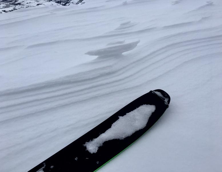
A more widespread and tricky MODERATE avalanche danger exists for Wind Drifted Snow on a variety of aspects at the mid and upper elevations. These hard windslabs are unmanageable and should be avoided.
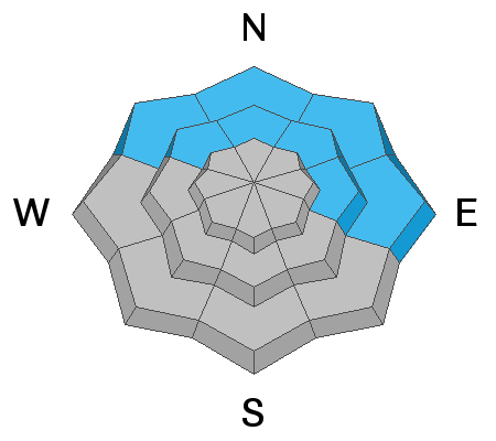
There is also a MODERATE danger for Wet Snow avalanches found at the low and mid elevation northerly facing terrain. Avoid being in terrain traps and gullies where wet snow can pile up. Roller balls and wet loose sluffs are a sign that the snow is becoming unstable.
Low
Moderate
Considerable
High
Extreme
Learn how to read the forecast here
Special Announcements
Final report for the Dutch Draw avalanche fatality is available HERE. Consider donating to the Matt Tauszik Memorial Fund to help his wife and young son.

Stocking Stuffers: Thanks to the generous support of our Utah ski resorts and Ski Utah, we have discount lift tickets available. All proceeds from these go towards paying for avalanche forecasting and education! Get your tickets here.
Weather and Snow
Under partly to mostly cloudy skies the southerly winds continue to blow across the mid and upper elevation terrain with speeds of 15-30 mph gusting to 45 mph, depending on your location. Ogden Peak is currently reading wind speeds of 30-40 mph with gusts into the 50's. Mountain temperatures hover in the mid 30's °F at elevations up to 8,500'. Above 9,000' the temperatures are below freezing. For today, we will continue to see thick clouds stream overhead and southerly winds, however, the wind won't be as strong as yesterday. A series of weak storms will impact the state beginning overnight and lasting into Thursday. This system doesn't look all that impressive for northern Utah, but, we could see 5-10" of new snow by Friday morning.
Warm temperatures and strong winds have taken their toll on the snow surface. Southerly aspects and low elevations now have sun/heat crusts. Upper elevation exposed northerly terrain is a moon scape with hard wind board scattered around the slope. Soft settled powder remains in the mid and upper elevation wind and sun sheltered terrain.

Our Week in Review - summarizing the significant weather and avalanche events of the past week - can be found here.
Photo: Doug Wewer - Showing the wind eroding the snow surface.
Recent Avalanches
Yesterday, a skier found a hard wind slab that broke around him/her 1-3' feet deep and 175' feet wide. They were caught and carried. They deployed their airbag and was buried up to their armpit in debris. No injuries. The slope angle was measured at 31° degrees in steepness.
Skiers on Saturday triggered two new wind slab avalanches. One was quite small at 4" deep and 15' wide, but the other was in more heavily wind loaded terrain. This second slide was 1-3' deep and perhaps 100' wide on a northeast facing slope at 8100'. Mike Fogg has an excellent observation from Monte Cristo HERE.
Ad
Avalanche Problem #1
Wind Drifted Snow
Type
Location
Likelihood
Size
Description
The southwest winds have and will continue to scour and erode any available snow and deposit it in the form of soft and hard wind drifts in the mid and upper elevations, even in odd and unusual locations. Yesterday, we had a skier trigger hard wind slab, taking a ride in the avalanche. This should be a hint that these drifts are not to be messed with. In some areas, these drifts may land on weak snow surfaces formed over the past week and may be surprisingly sensitive and possibly triggered from a distance. These areas are more likely found in the sun and wind sheltered terrain where the snow surfaces are susceptible to decay.
Wind drifts are often smooth, scalloped, and rounded . Soft wind slabs you're "in the snow" with your sled or skis; hard wind slabs you're "on top of the snow". Hard slabs are often trickier because they allow you to get well on to them before they collapse. For today, continue to look for and avoid rounded, pillowy, or hollow sounding snow.
Danger Trend: Steady to Increasing
Avalanche Problem #2
Wet Snow
Type
Location
Likelihood
Size
Description
Another night with temperatures above freezing at the low to mid elevations. Shady and sheltered snow surfaces have had a poor-at-best refreeze and may become wet and unstable. There'll be no secrets, though - you'll see if the snow surfaces are deteriorating (rollerballs, sluffing) make decisions accordingly. Avoid being in and above terrain traps where the snow may pile up more deeply.
General Announcements
This information does not apply to developed ski areas or highways where avalanche control is normally done. This forecast is from the U.S.D.A. Forest Service, which is solely responsible for its content. This forecast describes general avalanche conditions and local variations always occur.