Forecast for the Ogden Area Mountains

Drew Hardesty
Issued by Drew Hardesty on
Saturday morning, December 14, 2019
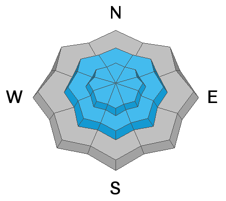
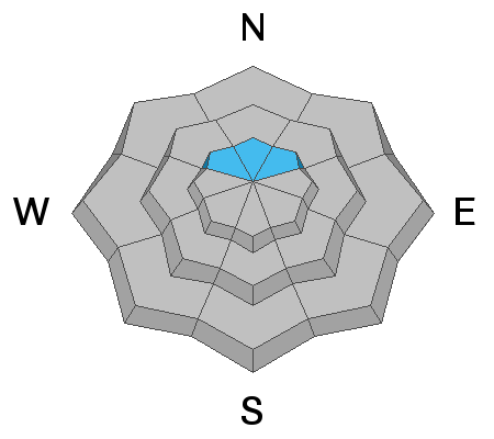
The avalanche hazard is CONSIDERABLE at the mid and upper elevations. Human triggered avalanches are probable with natural avalanches possible during periods of higher snowfall intensity or wind. New snow avalanches may be enough to step down near the ground at the upper elevation northerly slopes.

Caution is warranted: Avoid being on or underneath slopes steeper than 30 degrees on these mid and upper elevation aspects.

If this is too much, enjoy the powder at one of our world class ski resorts.
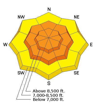
Low
Moderate
Considerable
High
Extreme
Learn how to read the forecast here
Special Announcements
Thanks to the generous support of our Utah ski resorts and Ski Utah, we have discount lift tickets available. All proceeds support the UAC. Get your tickets HERE.

Consider taking an avalanche class, there are many different options. Click on the Education menu for a full list of classes from the UAC and other providers. Check out the Know Before You Go eLearning program for free, online, avalanche classes.
New UAC podcast - Betting Your Life - Why Forecasting is Poker and Not Chess - A Conversation with Jenna Malone
Weather and Snow
Blockbuster.
It snowed another 4-6" overnight and it's still snowing. Storm totals are now nearly 2' with (2.25-3.0" SWE).
Temperatures slowly warmed overnight and are in the mid to upper 20s.
Winds are westerly, blowing 15-20mph and will shift to the northwest during the day.

We've been working on revamping our Mountain Weather page - you can find it in the Forecast section of the Menu above.
Recent Avalanches
Avalanche control teams triggered numerous new snow avalanches yesterday, particularly along the upper elevations of the Ogden Skyline.
Ad
Avalanche Problem #1
New Snow
Type
Location
Likelihood
Size
Description
Storm snow and wind slab avalanches will be sensitive to provocation on many slopes of the mid and upper elevations today and natural activity may occur during periods of high snowfall rates. These may be up to 3' deep in heavily wind loaded terrain.
Avalanche Problem #2
Persistent Weak Layer
Type
Location
Likelihood
Size
Description
This will be a good test for the patchwork of early season faceted snow found at the base of the snowpack on steep northerly terrain of the upper elevations. This may take a particularly heavy thump like any new snow or wind slab avalanche which may step down to this suspect layering, creating a much larger and more deadly avalanche.
Sidecountry areas such as Hell's Canyon should be considered very dangerous today.
Additional Information
Avalanche Rescue is the real deal. You must feel completely confident that you can pull off an avalanche rescue if things go wrong today. Even this may not save the day as roughly 1/4-1/3 of all fatalities are due to traumatic injury. If there is an avalanche accident, CALL 911 and say this is a backcountry emergency. But make no mistake - YOU NEED TO PULL OFF THE RESCUE, AND MOST LIKELY YOU HAVE ONLY 15-20 MINUTES TO DO SO.
KNOW THAT RESCUE TEAMS ASSUME A GREAT DEAL OF RISK in coming in to help injured or avalanched parties. AS ALWAYS, PLEASE OBEY CLOSURES AND UPHILL POLICY RESTRICTIONS AS INDICATED BY THE SKI AREAS.
General Announcements
This information does not apply to developed ski areas or highways where avalanche control is normally done. This forecast is from the U.S.D.A. Forest Service, which is solely responsible for its content. This forecast describes general avalanche conditions and local variations always occur.