


Mark Staples
2015-2024 - Director, Forest Service Utah Avalanche Center
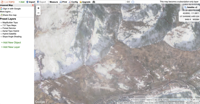
Using Caltopo, aerial photos, and other mapping apps with up-to-date satellite imagery
In the Wasatch Mountains and many other mountain ranges in Utah, mapping early season snow cover can help us predict where some of the most deadly avalanches can occur. Often the early season snow becomes weak, sugary, and faceted. This early season snow becomes a major avalanche problem as it forms a persistent weak layer on which both soft slab and hard slab avalanches can fail.
Early season satellite and aerial imagery is a great way to find out where the early season snow existed prior to snowfall that blankets the mountains and hides this deadly weak layer of old snow. These products are a great tool, but that is all. They area tool for us to do our homework. They are no replacement for field work. In the field, it's best to use a compass to know which direction slopes face. Second and most important is to dig a snowpit on a low angle slope that has the same aspect and elevation to the slope you hope to ski or ride. Imagery and you compass can tell you what you might expect to find, but your life depends on knowing for sure what is under your feet. Often it can be very obvious as you can see in this photo or this photo. Stability tests can also help you determine if these weak layers of old snow exist like one in this video.
A great discussion on using Cal Topo can be found on the Wild Snow website HERE.
Be careful when you take tools like these and apply them on smaller scales. A skier died in an avalanche in Colorado on Jan 5, 2019. They had estimated slope angles with a mapping tool the night before but never measured them in the field. Small errors like this can be deadly. Read the full accident report HERE.
From Greg:
What I really like is the snow coverage as it helps you get an idea where there is and isn't snow - seems pretty helpful right now. I agree about the shading not being granular enough - it's enough to miss the micro-slopes that are steeper, but may not show up on caltopo. I'm also unsure how often it pulls satellite data (tried looking this up but no luck) so imagery may be dated. I did find the idea of choosing weather stations intriguing, but when I did choose that option, the standard wx stations in the central Wasatch didn't show up.

From a trip planning standpoint it seems very useful - I just looked at a map on an area that I've traveled to in the Tetons and something like this would have been easier than paper topos.
I also think it could be an interesting educational tool to help people identify avalanche terrain when you add the shading layer.
The tool itself seems a bit clunky to work with, and the interface could be cleaner.
Images below from Caltopo with satellite view of snow cover from November 19, 2019. These images can be loaded onto mobile apps like Gaia. Clicking on the image below will take you to Caltopo with the appropriate layers preselected; HOWEVER, see the next image for selecting the appropriate timeframe for the satellite imagery. It will default to the most recent imagery which will show all slopes snow covered.