Forecast for the Ogden Area Mountains

Drew Hardesty
Issued by Drew Hardesty on
Saturday morning, April 18, 2020
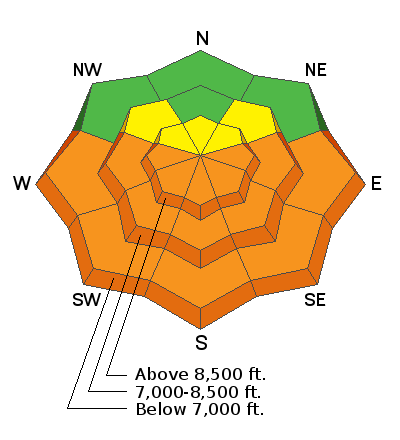
I expect the danger for wet avalanches to rise toward CONSIDERABLE today with sun and daytime warming. Both natural and human triggered wet avalanches will be likely on all aspects but true north. Areas of MODERATE danger exist for shallow pockets of wind slab and lingering soft slabs from the recent storm.
Low
Moderate
Considerable
High
Extreme
Learn how to read the forecast here
Special Announcements
The Avalanche Research Program at Simon Fraser University is conducting an online survey to examine how people use avalanche safety information. They want to hear from all backcountry users to understand how they process information provided in public avalanche forecasts. Anyone who completes the survey before May 15th will be entered to win cash prizes.
Weather and Snow
Skies are partly cloudy this morning with generally light westerly winds. The highest anemometers have speeds of 20-25mph with gusts near 30. Mountain temps are in the upper 20s to low 30s. For today, we'll see partly cloudy skies, light west to northwest winds and temps rising to near 40°F along the ridgelines and 50°F down low. Riding conditions have been quite good the past couple of days on the recent storm snow.
Doug Wewer, Derek DeBruin and others have been our recently and you can find their observations in the menu above.
Recent Avalanches
There were no reports of significant avalanche activity yesterday, but Doug Wewer reported the snow becoming damp with heating; allowing him to intentionally trigger some wet sluffs.
Ad
Avalanche Problem #1
Wet Snow
Type
Location
Likelihood
Size
Description
Much warmer temperatures will get the wet avalanches moving earlier today and will even include some northeast and northwest aspects at the mid and low elevations. The cooler temps kept most wet activity in check yesterday but wet avalanches will be more active today. Both wet loose and wet slab avalanches will be likely, running fast and far on the slick underlying crusts. Pinwheels and rollerballs are signs to start moving to lower angle terrain.
Avalanche Problem #2
Wind Drifted Snow
Type
Location
Likelihood
Size
Description
This section will include isolated areas of lingering soft slab instabilities, fresh wind drifts up high, and cornice fall. These all warrant some mention for extra caution in the higher elevations, particularly in unforgiving terrain. As Derek mentioned in his report yesterday, cornices still need to be given the proper respect and margin/distance near the ridgelines.
Additional Information
Information on outdoor recreation - The State of Utah created this webpage with information about recreating on both state and federal public lands during the current health crisis.

Skiing and riding at closed ski resorts - Some resorts allow access now, and some do not. Please check HERE for the latest info on ski area access.

New to the backcountry (including riding at closed resorts) - Watch the award-winning, 15 minute Know Before You Go video, or take the 5-part, free online-learning series.
General Announcements
This information does not apply to developed ski areas or highways where avalanche control is normally done. This forecast is from the U.S.D.A. Forest Service, which is solely responsible for its content. This forecast describes general avalanche conditions and local variations always occur.