Forecast for the Ogden Area Mountains

Drew Hardesty
Issued by Drew Hardesty on
Monday morning, March 9, 2020
Fresh wind drifts have a MODERATE DANGER in the higher elevations, while wet avalanches continue a MODERATE danger at the low to mid elevations. Human triggered avalanches remain possible on steep slopes. IF the sun pokes through or greenhousing occurs, wet avalanches will be more likely.
Low
Moderate
Considerable
High
Extreme
Learn how to read the forecast here
Special Announcements
The UAC's Avy Awareness Auction is currently underway with tons of great gear, jewelry, artwork and experiences available. Visit the auction page HERE to help support the UAC's spring avalanche awareness and outreach efforts.

If you are in the Salt Lake Area - Join The Utah Avalanche Center at Backcountry HQ on March 12th as Craig Gordon leads an interactive discussion on current Wasatch snowpack conditions, a recap of this season’s close calls and accidents, how to stay on the right side of the fracture line, and predictions for the rest of the season. Space is limited, registration is required. Register HERE.
Weather and Snow
Skies are mostly cloudy-becoming-overcast. Mountain temps dropped into the mid-20s overnight but have since rebounded in the pre-dawn hours. Many stations have temps in the low 30s as of 5am.
The south to southwest winds picked up overnight and are blowing 20-30mph with gusts to 45. Gusts along the highest elevations of the Ogden Skyline are in the 50s.
Storm totals are roughly 6-8" with 0.6-0.8" snow water equivalent. Riding conditions have dramatically improved.
Recent Avalanches
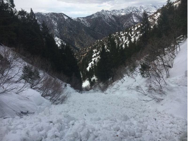
Ski area avalanche teams reported isolated wind drifts and shallow sluffing in the storm snow, but more significant was the wet loose avalanches gouging down into weak unconsolidated grains at the lower elevations. Some of debris piled up deeply in terrain traps. In the Logan area mountains, a skier was caught and carried in wet avalanche debris for 800 vertical' in mid-afternoon on a north facing slope at 7800'. The party is unsure if they triggered the avalanche or if it was a natural from above.
Ad
Avalanche Problem #1
Wind Drifted Snow
Type
Location
Likelihood
Size
Description
Human triggered soft slabs are possible in steep wind drifted terrain. These wind drifts will be more prominent in the upper elevation, northwest to northeast to southeast facing terrain, but pockets of wind drifts may be found on all aspects. These drifts should be reactive to cornice drops and ski cuts but best left alone and avoided. Look for the smooth and rounded, scalloped appearance of any wind drifts. These will be increasingly stubborn to trigger by the afternoon.
Avalanche Problem #2
Wet Snow
Type
Location
Likelihood
Size
Description
Wet avalanches are notoriously challenging to forecast. At the low to mid elevations, the refreeze was likely fleeting and superficial at best. With the warm and rebounding temperatures, wet loose avalanches may still be triggered today and gouge down into wet unconsolidated grains, primarily (but not limited to) in northerly aspects. Avoid being in or above terrain traps and steep walled gullies where wet snow can set up like concrete and pile up deeply.
General Announcements
This information does not apply to developed ski areas or highways where avalanche control is normally done. This forecast is from the U.S.D.A. Forest Service, which is solely responsible for its content. This forecast describes general avalanche conditions and local variations always occur.