Forecast for the Ogden Area Mountains

Mark Staples
Issued by Mark Staples on
Thursday morning, March 26, 2020
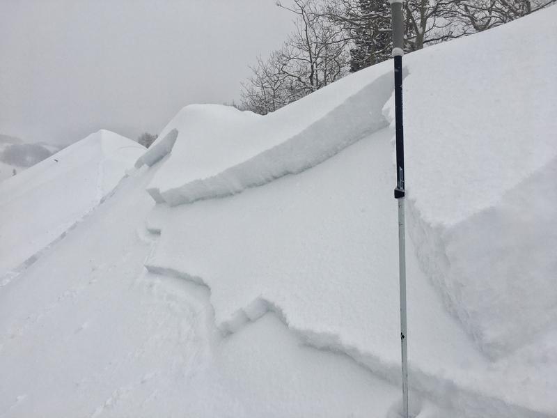
Today the avalanche danger is CONSIDERABLE at upper elevations and mid elevations. With so much new snow, there is a lot of uncertainty about how well it is bonded to itself and a conservative approach would be best.
The danger at low elevations is MODERATE.
Low
Moderate
Considerable
High
Extreme
Learn how to read the forecast here
Special Announcements
UAC operating schedule - We will continue issuing regular avalanche forecasts into mid-April.
Spring Awareness Campaign - The UAC counts on donations from the backcountry community. We know these are uncertain times, and any donation during our awareness campaign will help us continue providing avalanche forecasting and education.
CDC Guidelines - Even in the backcountry and in parking lots, please follow CDC guidelines like limiting group size and keeping a distance of at least 6 feet from other people to protect yourself and others. Don't carpool with anyone outside of your household. Read the guidelines HERE.
Taking risks - Be extra conservative to avoid the risk of accidents, which can stress the capacity of our medical system.
Skiing and riding at closed ski resorts - Some resorts allow access now, and some do not. Please check HERE for the latest info on ski area access.
New to the backcountry (including riding at closed resorts) - Watch the award-winning, 15 minute Know Before You Go video, or take the 5-part, free online-learning series.
Weather and Snow
Snow: Overnight 6-9 inches of snow fell. Snow totals this week are impressive with just over 2 feet of snow (containing about 2.5 inches of water).
This morning temperatures range from the upper teens F to the upper 20s F. Winds were mostly light yesterday but increased some yesterday afternoon and overnight. This morning winds from the north above 9000 feet are averaging 5-15 mph and gusting 20-30 mph.
Today, steady snowfall should continue into mid morning and then becoming more intermittent with another 3-5 inches of snow possible. Cloudy skies will prevent temperatures from warming beyond the lower 30s F. Winds should calm later this morning.
The new snow is generally right side up on wind-sheltered slopes - meaning the upper layers are lighter and lower layers are denser HOWEVER gusty winds this morning created a denser layer of snow on top of lighter snow.
Recent Avalanches
There have been no reported avalanches in the Ogden area. Further south in the Cottonwood Canyons, there were 8 reported avalanches that were soft slabs of new snow. Below is a photo of one I triggered on Little Water Peak. Many of these slides failed on graupel that fell earlier this week.
Ad
Avalanche Problem #1
New Snow
Type
Location
Likelihood
Size
Description
There is simply a lot of new snow in the Ogden area mountains. Within that new snow are layers of various densities and different crystal types. With more snow falling overnight, the added weight and stress of this new snow will likely keep any instabilities alive. One layer is some graupel that fell earlier this week and produced unstable results in snowpack tests near Snowbasin.
I wouldn't be surprised to hear of soft slab avalanches in the new snow today breaking 1-2 feet deep. These types of instabilities can heal quickly this time of year but I wouldn't trust them today. ADDITIONALLY, any amount of wind-blown snow will add further weight and stress.
At low elevations, the snow became quite wet yesterday. This wet snow should be well bonded to the new snow that fell overnight especially since temperatures dropped into the upper 20s F at those elevations.
For today, I'd play it conservative and stick to low angle slopes less than 30 degrees in steepness. Now is not a good time to take chances.
General Announcements
This information does not apply to developed ski areas or highways where avalanche control is normally done. This forecast is from the U.S.D.A. Forest Service, which is solely responsible for its content. This forecast describes general avalanche conditions and local variations always occur.