Forecast for the Ogden Area Mountains

Nikki Champion
Issued by Nikki Champion on
Sunday morning, March 22, 2020
This morning most terrain has a generally LOW avalanche danger, but a MODERATE danger will develop for steep solar slopes as small, loose wet avalanches become possible mid-day with peak temperatures. Due to increased winds, small pockets of fresh wind drifts may also be found along the upper elevation north-facing ridgelines.
Evaluate terrain carefully, and pay attention to your aspects and timing.

Additionally, keep in mind that closed ski resorts are performing no avalanche control work and must be treated as the backcountry.
Low
Moderate
Considerable
High
Extreme
Learn how to read the forecast here
Special Announcements
We know there is a lot of uncertainty regarding the Coronavirus, but the Utah Avalanche Center is planning to continue issuing regular avalanche forecasts into April.

Uphill Travel at Ski Areas - Some closed resorts are offering limited uphill access, and policies may change daily. The latest information about uphill access from Ski Utah is posted HERE.
Travel in the mountains is still a relatively safe way to get out, exercise, find joy, and maintain a sense of normalcy. During these challenging times, the UAC asks that you do not carpool with people who live outside of your household, keep your groups small, and don’t have social gatherings at the parking lot before or after your day out. Please take extra precautions to avoid the risk of accidents that could require medical attention. Any backcountry accident can stress the capacity of our medical system.
Weather and Snow
This morning, mountain temperatures are in the low-30s F at trailheads and upper-20s F at ridgelines. Winds are southwesterly and have increased overnight, currently averaging in the mid-teens with gusts of 30 mph at mid-elevations, and gusts near 35 mph at upper-elevations.
Today, a weak high pressure will build over the area and bring mostly sunny skies, mountain temperatures in the mid-30s F, and southwesterly winds averaging 5-15 mph at mid-elevations and 15-25 mph, with gusts up to 30 mph at upper elevations.
The next round of measurable precipitation will begin late tomorrow morning, or early afternoon before a cold front pushes through the area Tuesday into Wednesday.
Recent Avalanches
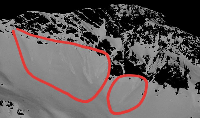
Many natural wet-loose avalanches reported in the Ogden area backcountry.
Below is a photo from the shed cycle on the Willard Side of the headwall. (Photo: D. DeBruin) See the full observation HERE.
As always, you can find more details in the Observations and Avalanches tab above and locations of these areas HERE
Ad
Avalanche Problem #1
Wet Snow
Type
Location
Likelihood
Size
Description
Last night's below freezing temperatures should keep the snow surface cooler but as the day heats up and the sun comes out in the Ogden area mountains the snow will get wet and you should be able to trigger small loose wet avalanches. These usually start at your feet and fan out below you. However, watch out for these slides happening naturally especially if you are in a gully or any confined terrain where a small one could pile up deeply.
Look for signs of wet snow like rollerballs.
Avalanche Problem #2
Wind Drifted Snow
Type
Location
Likelihood
Size
Description
Increased southwesterly winds yesterday into this morning may have transported some lingering dry snow and created small pockets of recent-wind drifted snow in upper elevation north-facing terrain features, such as ridgelines and cross-loaded gullies.
Avoid terrain features with obvious signs of wind-drifted snow.
Additional Information
If you are new to backcountry skiing (perhaps you are hiking uphill at a closed resort), the UAC has published an award-winning educational series Know Before You Go. This includes:
- A basic 15-minute avalanche awareness video
- A free online-learning series with five interactive courses
But don't stop here. Commit yourself to take an avalanche awareness class during the 2020/21 season!
General Announcements
This information does not apply to developed ski areas or highways where avalanche control is normally done. This forecast is from the U.S.D.A. Forest Service, which is solely responsible for its content. This forecast describes general avalanche conditions and local variations always occur.