Forecast for the Ogden Area Mountains

Nikki Champion
Issued by Nikki Champion on
Wednesday morning, February 5, 2020
Today a MODERATE danger exists on all mid and upper elevation aspects where fresh slabs of wind drifted snow exist.
Shallow soft slabs and sluffing remains possible in the new snow on steep slopes at the mid and upper elevations.
A LOW avalanche danger is found on north-facing mid-elevation slopes and all slopes under 7,000' in elevation where generally safe avalanche conditions exist.
Heads up: A warm, wet, and windy storm will rapidly raise the avalanche hazard over the next few days.
Low
Moderate
Considerable
High
Extreme
Learn how to read the forecast here
Special Announcements
Discounted lift tickets - Thanks to the generous support of our Utah ski resorts and Ski Utah, all proceeds from these ticket sales go towards paying for avalanche forecasting and education! Get your tickets here.
Kory Davis of Ogden Avalanche, Nichole Dye of Powder Mountain and Drew will be at Rooster's downtown Ogden Thursday 7pm to talk about avalanche accidents and close calls. Join them!
Weather and Snow
Mountain temperatures are still cold! Trailhead temperatures are currently hovering near 10 F, while the uppermost ridgetops near 9,600 feet are right below zero F. Winds are currently northwesterly, and southwesterly averaging between 15-20 mph, with gusts above 25 mph. The uppermost ridgetops are gusting up to 35 mph.
Today, temperatures will remain cold averaging in the low teens F. Winds should remain northwesterly with a few gusts up to 45 mph, and increasing throughout the day into the evening. Skies will be partly cloudy until snow lightly begins this afternoon and picks up around midnight.
Looking forward, we have a storm on the horizon that could bring up to 2 feet of heavy, warm snow in combination with moderate to strong winds. Below is the briefing from the National Weather Service.
Recent Avalanches
Yesterday, there were reports of avalanches occurring Monday night into Tuesday.
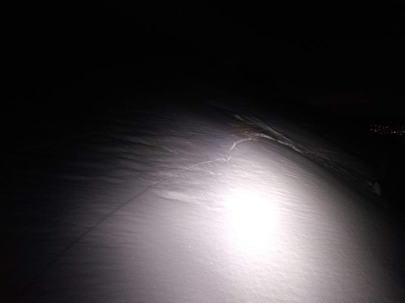
In Farmington Benches, one small wind slab was triggered perpendicular to the road and ran 50 feet wide and 5 feet long. This avalanche seemed to fail on the new snow/old snow interface.
Photo of avalanche from Farmingto Canyon (Photo: Jack)
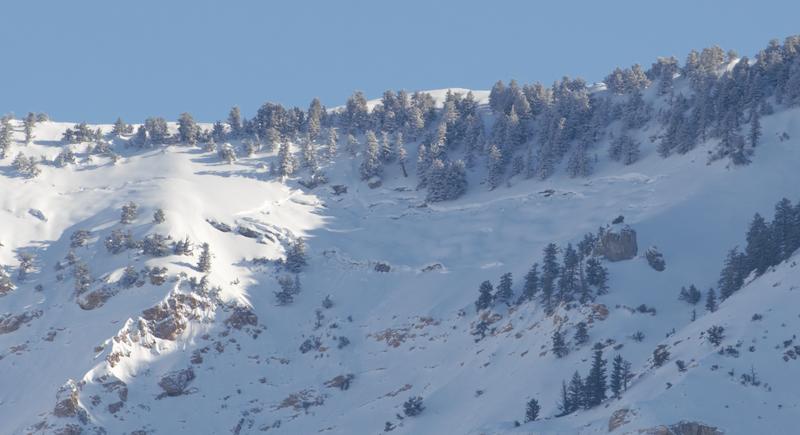
Yesterday a glide avalanche was also reported. On Ben Lomond, on a west aspect at 8,000 ft.
Great photo of the glide avalanche from D. Wewer. Check out his full observation here, that has other photos of recent avalanche activity from the Ben Lomond area.
Minor sluffing and an occasional shallow wind drift triggered by ski area control teams.
Ad
Avalanche Problem #1
Wind Drifted Snow
Type
Location
Likelihood
Size
Description
Since Monday we have plenty, of light, low-density snow available for transport. Following Monday's varying depths of low-density snowfall, we have had winds strong enough to create sensitive wind drifts and these winds will be increasing steadily throughout the day. As the winds continue to increase, these wind drifts will become more widespread.
In the Ogden area mountains, the winds have been both northerly and southerly for the last 24 hours and should switch to northwesterly into the evening. Yesterday, the wind loading was reported to be is "backward" relative to typical at all elevations. Today, I would expect to find sensitive slabs of wind drifted snow at all upper and mid-elevation slopes, especially along with terrain features such as ridgelines, sub ridges, and gullies.
Look for slopes with any signs of wind drifted snow, such as cracking, hollow noises, and pillow-shaped snow and avoid those slopes.
Great photo of wind loading and new wind lips forming on Ben Lomond. (Photo: D. DeBruin)
Avalanche Problem #2
New Snow
Type
Location
Likelihood
Size
Description
Monday we got anywhere between 5-14 inches of low-density snow, which fell on a variety of smooth surfaces. The new snow has been reported to be running far and fast in steep terrain. In protected areas that got higher snowfall and have not yet been affected by the wind, I would still expect shallow soft slab and small point release avalanches in this new snow.
Be especially thoughtful of this while traveling above terrain traps, cliff bands and features which the debris could pile up.
The good news: These can be well managed through avoidance, think about what is above and below you, and with ski cuts.
Additional Information
This afternoon we have another system moving through. It is predicted to start cold, and transition to a heavy, warm, wet snowfall. This is known as an upside-down storm, which occurs when a storm deposits denser snow over less dense snow, in turn rapidly creating a slab/weak layer combination.
In our situation, this warm heavy snow is going to fall on the light, low-density snow from Monday. Following Monday, we have had two days of cold temperatures, which will have just further weakened the new snow. Cold temperatures are what drive faceting, one of the fundamental processes to a weak layer. As the snow totals begin to increase this evening and into tomorrow morning the avalanche danger will rapidly be on the rise.

Tree-well immersions and asphyxiation should be on the radar in areas that received the most snow. Frost-bite is of concern. Roof-alanches should also be on the radar in the coming days as the temperatures increase.
General Announcements
This information does not apply to developed ski areas or highways where avalanche control is normally done. This forecast is from the U.S.D.A. Forest Service, which is solely responsible for its content. This forecast describes general avalanche conditions and local variations always occur.