Forecast for the Ogden Area Mountains

Drew Hardesty
Issued by Drew Hardesty on
Sunday morning, February 27, 2022
A MODERATE danger exists in the Ogden area mountains. Natural and human triggered wet avalanches are likely on steep east to to south to west facing aspects with sun and warming today. Human triggered soft slab avalanches are possible along the higher elevation bands as well as the northwest to east facing aspects on the north side of the compass. Expect to find loose dry sluffs on polar aspects and isolated pockets of wind slabs in the upper elevations.
Low
Moderate
Considerable
High
Extreme
Learn how to read the forecast here
Weather and Snow
Skiing and riding conditions are the best they've been in two months.
Skies are clear with west winds in the mountains. Mt Ogden is gusting to 25mph. Temperatures have rapidly warmed into the mid to upper 20s up high, the teens down low.
Today starts clear with clouds expected to stream in from the west. Winds will be 15-20mph along the ridgelines. Temps will rise into the mid to upper 30s. Weak ridging will keep fair weather for the week with temps soaring into the 40s by Wednesday. A storm is slated for Friday. Perhaps the first of many...
Recent Avalanches
Snowbasin patrol reported that a skier triggered a size 2 (big enough to bury you) wind slab on a steep solar wind loaded aspect in their periphery yesterday. Further north, skiers noted long running loose sluffs off the Ben Lomond/Willard headwall.
Ad
Avalanche Problem #1
Wet Snow
Type
Location
Likelihood
Size
Description
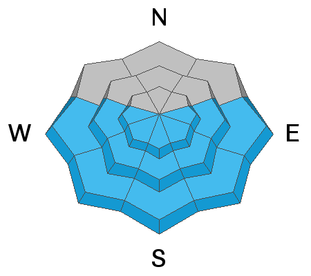
Natural and human triggered wet avalanches are expected today.
Rapidy warming temperatures and - initially - direct sun wil rapidly destabilize the recent storm snow on east then south then westerly facing aspects. These wet sluff and potentially wet slab avalanches will run fast and far on the slick underlying crusts with wet concrete-like debris piling up deeply in runout zones below. Pinwheels, rollerballs and damp sluffs will be early indicators of instability. Be very aware of changing conditions within the snow as it becomes damp and unstable - DO NOT OVERSTAY YOUR WELCOME ON THE STEEP SOLAR ASPECTS. Plan your day accordingly.
*This should be your guidance heading into the morning. The cloud cover streaming in from the west today provides uncertainty on how this will affect the snow surfaces. The mid and upper level clouds may shield the snow from the full blast of the sun; and/or the clouds may provide for "greenhousing". This may accentuate the wet activity even on some lower elevation northerly terrain.
Avalanche Problem #2
Persistent Weak Layer
Type
Location
Likelihood
Size
Description
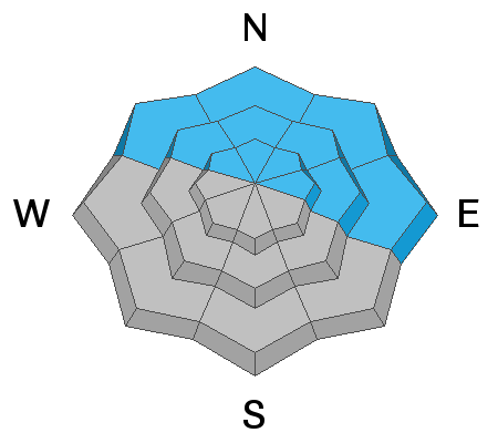
I suspect there may be a few booby traps out there. We have 6-12" of fresh snow over the past couple of days sitting over some crusts and very weak snow on the shady aspects. We know that we have weak snow; it's just that we don't know if we have enough new snow to tip the balance. Cracking and collapsing are signs of instability and snow tests are helpful. There is a lot of variability and uncertainty about this unstable layering so I would recommend staying on lower angle terrain with nothing steep above.
My observation in Broads Fork of BCC Friday looks at this more in depth HERE.
What to Do With Uncertainty?
  • If the game is rigged, choose not to play. In other words, owing to the high uncertainty and the nature of the problem, choose low angle slopes with nothing steep above. We rode low angle northerly terrain yesterday and it was the best in two months.
  • Choose aspects that do not harbor the PWL: we know that northwest through east aspects harbor the PWL. West to southwest to south to southeast aspects do not harbor the PWL and these aspects will ride nearly as well today.
General Announcements
Who's up for some free avalanche training? Get a refresher, become better prepared for an upcoming avalanche class, or just boost your skills. Go to https://learn.kbyg.org/ and scroll down to Step 2 for a series of interactive online avalanche courses produced by the UAC.
This information does not apply to developed ski areas or highways where avalanche control is normally done. This forecast is from the U.S.D.A. Forest Service, which is solely responsible for its content. This forecast describes general avalanche conditions and local variations always occur.