Forecast for the Ogden Area Mountains

Nikki Champion
Issued by Nikki Champion on
Tuesday morning, February 25, 2020
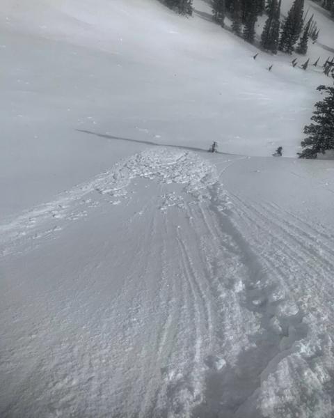
Today at all upper elevations the avalanche danger is MODERATE where fresh slabs of wind drifted snow exists. These wind slabs will be generally shallow and isolated to upper elevation terrain features that allow drifting snow to accumulate. These shallow slabs will be more sensitive on north-facing aspects, where they rest atop weaker snow.
All mid and low elevation slopes or slopes either stripped or untouched by the wind, the avalanche danger is LOW.
Low
Moderate
Considerable
High
Extreme
Learn how to read the forecast here
Special Announcements
The UAC's Avy Awareness Auction is currently underway with tons of great gear, jewelry, artwork and experiences available. Visit the auction page HERE to help support the UAC's spring avalanche awareness and outreach efforts.

A new version of the UAC IOS application is now available on the Apple App Store. This version fixes many of the issues that occur when running IOS 13. Download it now!
Weather and Snow
This morning, mountain temperatures are in the upper teens at trailheads and hovering at 5 F at ridgelines. Since late last night, the winds have been gradually decreasing but still elevated, this morning they are northerly and averaging 10 - 20 mph with gusts up to 26 mph at mid-elevations, and averaging 20 mph and gusting near 39 mph at upper elevations. Yesterday's storm totals were around 1 inch of snow (.03 - .05 inches of water).
Today, high pressure will build over the area bringing sunny and clear skies, temperatures in the mid-20s F and decreasing winds. Winds will be northwesterly averaging 5-15 mph with gusts below 25 mph at mid-elevations. The upper elevations could see gusts up to 35 mph.
Recent Avalanches
Yesterday, a few isolated wind slabs were reported on upper elevation slopes during control work in the ski resorts.
No new avalanches reported in the Ogden area backcountry.
Ad
Avalanche Problem #1
Wind Drifted Snow
Type
Location
Likelihood
Size
Description
The winds have finally begun to decrease. The last two days of strong winds in combination with a few inches of snow will have drifted snow and formed fresh slabs today. These wind drifts will be very small, as they only had a few inches of snow to move around, but with such strong winds, any snow that could be transported will have been transported.
Look for shallow slabs of wind drifted snow on isolated upper elevation terrain features that snow could be deposited, such as ridgelines and gullies. While these slabs will be primarily on the south and east end of the compass, such high winds can deposit snow on all aspects. Any fresh wind slabs on the north aspects will be easier to trigger since it will be resting on weak recrystallizing powder.
Look for any slopes with signs of wind drifted snow, and avoid those slopes.
A photo from Cardiac Ridge in the Central Wasatch of the shallow type of wind slabs you can expect to find today (Photo: M. White)
General Announcements
This information does not apply to developed ski areas or highways where avalanche control is normally done. This forecast is from the U.S.D.A. Forest Service, which is solely responsible for its content. This forecast describes general avalanche conditions and local variations always occur.