Forecast for the Ogden Area Mountains

Nikki Champion
Issued by Nikki Champion on
Sunday morning, February 23, 2020
A MODERATE danger exists on upper elevation north and east-facing terrain for triggering isolated slabs of wind drifted snow up to 2' deep.
At all other elevations, the avalanche danger is LOW. As the day heats up, minimize your exposure to loose, wet avalanches by avoiding steep slopes that are becoming noticeably wet.

Remember a mostly low avalanche danger, doesn’t mean “no avalanche danger”. Continue to evaluate snow and terrain carefully.
Low
Moderate
Considerable
High
Extreme
Learn how to read the forecast here
Special Announcements
Discounted lift tickets - Thanks to the generous support of our Utah ski resorts and Ski Utah, all proceeds from these ticket sales go towards paying for avalanche forecasting and education! Get your tickets here.
The UAC's Avy Awareness Auction is currently underway with tons of great gear, jewelry, artwork and experiences available. Visit the auction page HERE to help support the UAC's spring avalanche awareness and outreach efforts.

A new version of the UAC IOS application is now available on the Apple App Store. This version fixes many of the issues that occur when running IOS 13. Download it now!
Weather and Snow
Yesterday, temperatures were much warmer than previous days, hitting highs between 40-42 F in the mountains. The winds were light and southwesterly throughout the day, and the cloud cover moved in and out throughout the day letting in periods of sun.
This morning, mountain temperatures in the upper 20s F at trailheads, and low 20s F at ridgetops. Winds are northeasterly and generally light averaging 5-15 mph at mid-elevations. At the highest elevation, ridgetops gusts are 27 mph.
Today will be another sunny and warm one before a quick-hitting cold front moves through Northern Utah. Skies will be clear, and winds northeasterly in the morning and average 5-15 mph with gusts below 25 mph at mid-elevations. Upper elevation ridgelines will average 10-20 mph with gusts up to 40 mph. Throughout the day the winds will shift to northwesterly and increase into the evening as the temperatures drop. With the cold front, the Ogden area mountains could get 1-3 inches of snow.
Recent Avalanches
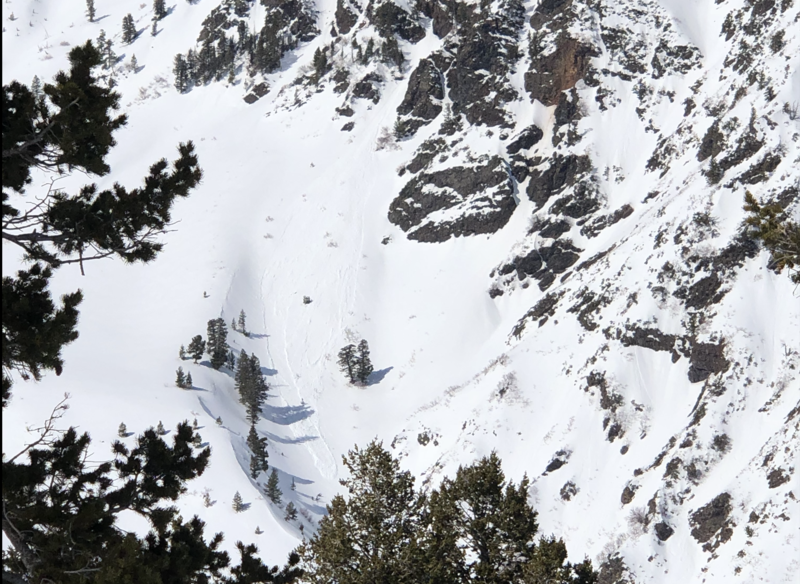
Yesterday's warm temperatures and high cloud cover lead to a few small wet-loose avalanches and roller balls in the backcountry and in resorts.
Photo of wet loose activity on steep terrain on Cutler Ridge yesterday (Photo: Ben)
Ad
Avalanche Problem #1
Wind Drifted Snow
Type
Location
Likelihood
Size
Description
Isolated wind drifts remain at the upper elevation aspects that didn't get baked in the sun yesterday. While their sensitivity is decreasing with time and warm temperatures, they still possess the potential to be triggered. Since these wind drifts sit on top of weaker snow, that is resting on top of the stout February 7th crust the structure may allow a rider to get well onto a slope before it fractures.
Avoid any wind-drifted slope on terrain steeper than 30 degrees. Signs of wind-drifting include denser pillows of snow or textured snow.
This photo from Cutler Ridge shows obvious signs of wind drifted snow on a slope. (Photo: D. DeBruin)
Avalanche Problem #2
Wet Snow
Type
Location
Likelihood
Size
Description
As the day heats up again, and the sun hits the slop. The surface snow will become moist, and you will be able to trigger small wet loose sluffs on steep slopes and natural wet snow avalanches may occur.
While these may not be large, they are enough to knock you off your feet and sweep you through consequential terrain. Look for signs of increased wetting of the snow, such as pinwheeling and loose wet avalanches off of rock features.
The key to wet snow is avoidance. When the snow becomes wet, move off steep slopes to lower angle terrain. Be aware of what is above you, and avoid travel beneath steep slopes, drainages, and gullies. Plan your exists carefully and consider avalanche runout zones when traveling today.
General Announcements
This information does not apply to developed ski areas or highways where avalanche control is normally done. This forecast is from the U.S.D.A. Forest Service, which is solely responsible for its content. This forecast describes general avalanche conditions and local variations always occur.