Forecast for the Ogden Area Mountains

Evelyn Lees
Issued by Evelyn Lees on
Thursday morning, December 27, 2018
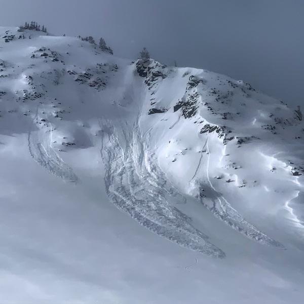
The avalanche danger for the Ogden mountains is MODERATE on all upper elevation slopes with recent drifts of wind blown snow. Wind drifts can also be found at the mid elevations, too, but the distribution will be more pockety, or isolated.
Travel one at a time in steep terrain, keep your partner in sight and be in position to get to them quickly should there be an avalanche.
Low
Moderate
Considerable
High
Extreme
Learn how to read the forecast here
Special Announcements
The new UAC IOS mobile app is now available on the app store. Check out the new "My Weather" feature.
Weather and Snow
Light snow is falling in the Ogden area mountains this morning, and another 2 to 4 inches of low density fluff is in the forecast for today. The powder is adding up, with snow totals in the Ogden area mountains since the 20th well over a foot. There is excellent powder on most aspects, sitting on a supportable crust, though a few slopes may be wind stripped down to the old crusts. Temperatures are currently in the single digits to low teens, and will probably remain in the teens today. Winds are generally from the northwest, and very light, even along the ridge lines - averaging 10 mph, with gusts in the teens.
Recent Avalanches
Reports from the Ogden area mountains yesterday were of wind drifts triggered by ski cuts and explosives, at both the upper and mid elevations. Some of these were large enough to carry and partially bury a person. Most were soft slabs, with just a few harder wind slabs mixed in.
An observation from one place in the Ogden area backcountry found no wind drifting below about 8,000'.
Ad
Avalanche Problem #1
Wind Drifted Snow
Type
Location
Likelihood
Size
Description
There is so much low density snow available for transport, I’m just holding my breath that the winds don’t pick up. If wind speeds increase and the snow starts to move where you are or you see plumes above you off the peaks, sensitive drifts are forming and instantly increasing the avalanche danger. And you’ll need to instantly change your travel plans. My greatest concern is the highest peaks and ridgelines if the winds pick up. Avoid travel on and below steep slopes with new wind drifted snow.
There are also a few older, denser wind drifts hidden beneath the snow snow, on a variety of aspects and around terrain features like the lee sides of ridge crests, gully walls, sub ridges and breakovers.
Out of the wind affected terrain, a few new snow sluffs can be triggered on steep slopes of all aspects. Consequences are important - even a small sluff can be serious if it takes you into trees, off a cliff or for a long ride, so choose your terrain carefully and use slope cuts to minimize the chance of going for a ride.. A beautiful Mark White photo showing what loose snow sluffs look like, Salt Lake area mountains.
General Announcements
This information does not apply to developed ski areas or highways where avalanche control is normally done. This forecast is from the U.S.D.A. Forest Service, which is solely responsible for its content. This forecast describes general avalanche conditions and local variations always occur.