Forecast for the Ogden Area Mountains

Issued by Nikki Champion on
Thursday morning, December 23, 2021
Thursday morning, December 23, 2021
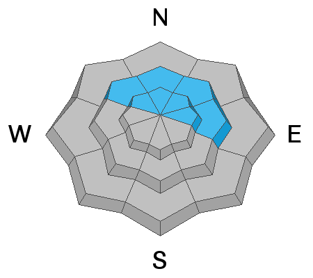
The avalanche danger is CONSIDERABLE on all steep upper elevations slopes facing northwest, through the north, through east, where recent storm snow and winds have created a dense slab of snow on top of a buried persistent weak layer. Avalanches initially triggered within the wind drifted snow or new snow can step down into deeper weaker layers.
The avalanche danger is MODERATE on upper-elevation slopes facing west, southwest, south, and southeast and all mid-elevation slopes.
The remaining aspects and elevations have a LOW danger.
As this storm moves into the area we will have dangerous avalanche conditions, and conservative decision-making will be essential today. Slab avalanches 1-3 feet deep, and hundreds of feet wide are likely. Low-angle terrain continues to be your best option.
HEADS UP: With lots of wind & snow in the forecast, the avalanche danger will be on the rise starting this morning and will continue to be dangerous through the holiday break. Please share the word with friends, family, and riding partners that conditions will continue to be dangerous and deadly here in Northern Utah, especially as the new snow stacks up. Be careful.

Low
Moderate
Considerable
High
Extreme
Learn how to read the forecast here