Forecast for the Ogden Area Mountains

Mark Staples
Issued by Mark Staples on
Sunday morning, November 15, 2020
The avalanche danger is MODERATE at mid and upper elevations. Look for and avoid thick, cohesive slabs of wind drifted snow which exist on many slopes. Getting caught in an avalanche with one of these wind slabs could seriously injure or kill you due to the trauma of being swept over rocks at 60 mph. Seek sheltered slopes that did not receive any wind drifted snow from yesterday's strong winds.
The avalanche danger is LOW at low elevations.
Please do everything possible to avoid getting hurt for yourself and for the greater good. As you decide where and how to travel in the backcountry, consider adding just a little extra margin of safety.
Low
Moderate
Considerable
High
Extreme
Learn how to read the forecast here
Special Announcements
I was very disappointed to read this observation from the Cottonwoods describing how people were riding in the backcountry. The most basic travel rule with regard to avalanches is that we only expose one person at a time, and we certainly don't ride above other people and put them at risk. Frankly, I'm at a loss for words and hope we won't see these same actions in the Ogden mountains.
Weather and Snow
Yesterday's storm delivered 12-17 inches of dense snow accompanied by very strong winds from the west that transported much of this snow. Settled snow depths are avergaing 20 inches of dense snow (~25% density).
This morning, winds shifted to the SW and are blowing 25 mph gusting to 35 mph. Temperatures are in the mid 30s F near 6000 ft and near 20 degrees F near 9000 ft. Overall temps are about 5 degrees warmer than yesterday.
Today, warm air is moving into the area and temperatures should climb in the upper 20s and low 30s F. Cloudy skies should produce 2-3 inches of snow. Much more snow should fall just a little further north (see image from the National Weather Service below). Winds will continue blowing from the SW about 10-20 mph.
Recent Avalanches
No avalanches were reported yesterday.
Ad
Avalanche Problem #1
Wind Drifted Snow
Type
Location
Likelihood
Size
Description
Yesterday's winds left few slopes untouched and formed thick cohesive slabs of wind drifted snow on many slopes. There is very little snow left for today's winds to transport; however, winds shifted to the SW and may have load a few slopes that didn't get loaded yesterday.
What are the odds of triggering these slabs? That's a hard question to answer exactly because the odds have been decreasing. Drew and his partners checked out the snow near Powder Mountain yesterday and didn't find any fresh wind slabs that were sensitive or showed obvious signs of instability. I wouldn't gamble with them just yet, because you'll lose if you find one that you can trigger.
The best travel advice is to avoid slopes with this wind drifted snow. This snow looks smooth, rounded, and pillowy and typically exist under cornices.
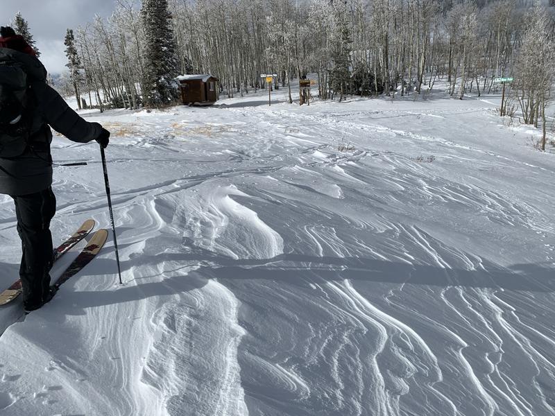
Evidence of strong winds transporting snow in this photo. Which direction were the winds blowing (answer below)?
In this photo, winds were blowing from the left to the right.
Additional Information
There are a few things to remember:
  1. Hitting rocks and stumps is a real danger. Don't end your season before it starts with an injury from hitting one of these obstacles.
  2. Early season avalanches are a real possibility. It doesn't matter if you are hiking, hunting, skiing, etc., be prepared with rescue gear and a partner. Many people have died during early season snowstorms. Listen to our UAC podcast episode The Day of Madness in Little Cottonwood Canyon about a bad day in November 2011 when many avalanches were triggered, including a tragic fatality.
  3. Ski resorts all have different uphill travel policies. These closed resorts that allow uphill travel can be great places to get in a little skiing especially in you know of a rock-free slope, but it should be treated as backcountry terrain. We will soon have an up to date resource on all the ski resorts individual policies.
Until more snow begins to fall, there are plenty of resources available to begin thinking about the season today:
  1. Check out the free online avalanche course material and e-learning materials available.
  2. Start looking at weather patterns in areas you plan to ski this upcoming winter. A full list of mountain weather stations can be found HERE.
  3. Freshen up on how to read the forecast page.
  4. Look over all of your gear and make sure everything is in good, working order.
  5. Sign up for an avalanche class! Get it on the schedule early.
Bonus Material! Listen to our podcast on Early Season Essentials with Bo Torrey
General Announcements
This information does not apply to developed ski areas or highways where avalanche control is normally done. This forecast is from the U.S.D.A. Forest Service, which is solely responsible for its content. This forecast describes general avalanche conditions and local variations always occur.